You are here: Home > Network List > TA - USArray Transportable Network (new EarthScope stations) Stations List
> Station I51A Listowel, ON, CAN > Earthquake Result Viewer
I51A Listowel, ON, CAN - Earthquake Result Viewer
| Earthquake location: |
Near Coast Of Guerrero, Mexico |
| Earthquake latitude/longitude: |
16.0/-98.3 |
| Earthquake time(UTC): |
2014/03/10 (069) 00:38:15 GMT |
| Earthquake Depth: |
8.4 km |
| Earthquake Magnitude: |
5.8 MWW, 5.9 MWC, 6.0 MWB |
| Earthquake Catalog/Contributor: |
NEIC PDE/NEIC COMCAT |
|
| Network: |
TA USArray Transportable Network (new EarthScope stations) |
| Station: |
I51A Listowel, ON, CAN |
| Lat/Lon: |
43.80 N/81.02 W |
| Elevation: |
376 m |
|
| Distance: |
31.3 deg |
| Az: |
24.471 deg |
| Baz: |
213.376 deg |
| Ray Param: |
0.07909661 |
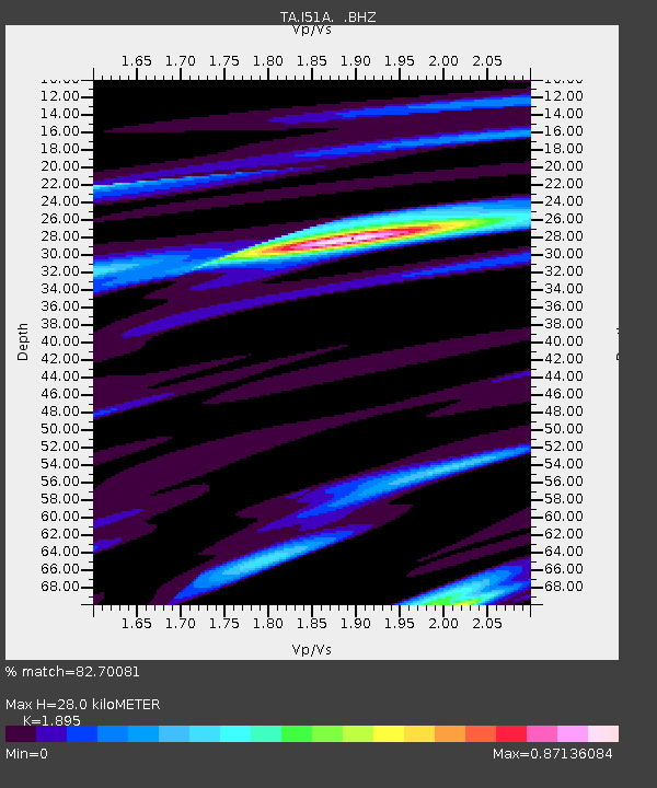
| Estimated Moho Depth: |
28.0 km |
| Estimated Crust Vp/Vs: |
1.89 |
| Assumed Crust Vp: |
6.53 km/s |
| Estimated Crust Vs: |
3.446 km/s |
| Estimated Crust Poisson's Ratio: |
0.31 |
|
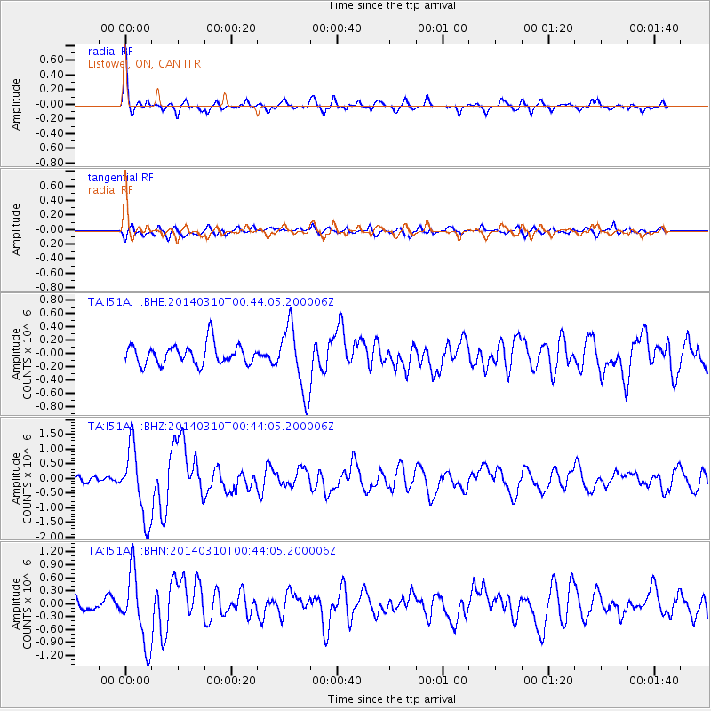
| Radial Match: |
82.70081 % |
| Radial Bump: |
400 |
| Transverse Match: |
61.63443 % |
| Transverse Bump: |
400 |
| SOD ConfigId: |
626651 |
| Insert Time: |
2014-04-21 02:49:52.591 +0000 |
| GWidth: |
2.5 |
| Max Bumps: |
400 |
| Tol: |
0.001 |
|
Signal To Noise
| Channel | StoN | STA | LTA |
| TA:I51A: :BHZ:20140310T00:44:05.200006Z | 7.3696036 | 1.2171184E-6 | 1.6515386E-7 |
| TA:I51A: :BHN:20140310T00:44:05.200006Z | 6.346374 | 8.301363E-7 | 1.308048E-7 |
| TA:I51A: :BHE:20140310T00:44:05.200006Z | 3.2496471 | 5.007254E-7 | 1.5408608E-7 |
| Arrivals |
| Ps | 4.1 SECOND |
| PpPs | 11 SECOND |
| PsPs/PpSs | 16 SECOND |


