You are here: Home > Network List > TA - USArray Transportable Network (new EarthScope stations) Stations List
> Station I58A Old Forge, NY, USA > Earthquake Result Viewer
I58A Old Forge, NY, USA - Earthquake Result Viewer
| Earthquake location: |
Near Coast Of Guerrero, Mexico |
| Earthquake latitude/longitude: |
16.0/-98.3 |
| Earthquake time(UTC): |
2014/03/10 (069) 00:38:15 GMT |
| Earthquake Depth: |
8.4 km |
| Earthquake Magnitude: |
5.8 MWW, 5.9 MWC, 6.0 MWB |
| Earthquake Catalog/Contributor: |
NEIC PDE/NEIC COMCAT |
|
| Network: |
TA USArray Transportable Network (new EarthScope stations) |
| Station: |
I58A Old Forge, NY, USA |
| Lat/Lon: |
43.69 N/74.97 W |
| Elevation: |
599 m |
|
| Distance: |
34.0 deg |
| Az: |
30.987 deg |
| Baz: |
223.035 deg |
| Ray Param: |
0.07796707 |
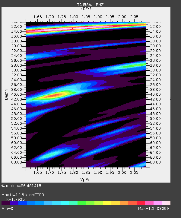
| Estimated Moho Depth: |
12.5 km |
| Estimated Crust Vp/Vs: |
1.79 |
| Assumed Crust Vp: |
6.419 km/s |
| Estimated Crust Vs: |
3.581 km/s |
| Estimated Crust Poisson's Ratio: |
0.27 |
|
| Radial Match: |
86.481415 % |
| Radial Bump: |
400 |
| Transverse Match: |
59.272274 % |
| Transverse Bump: |
400 |
| SOD ConfigId: |
626651 |
| Insert Time: |
2014-04-21 02:50:02.287 +0000 |
| GWidth: |
2.5 |
| Max Bumps: |
400 |
| Tol: |
0.001 |
|
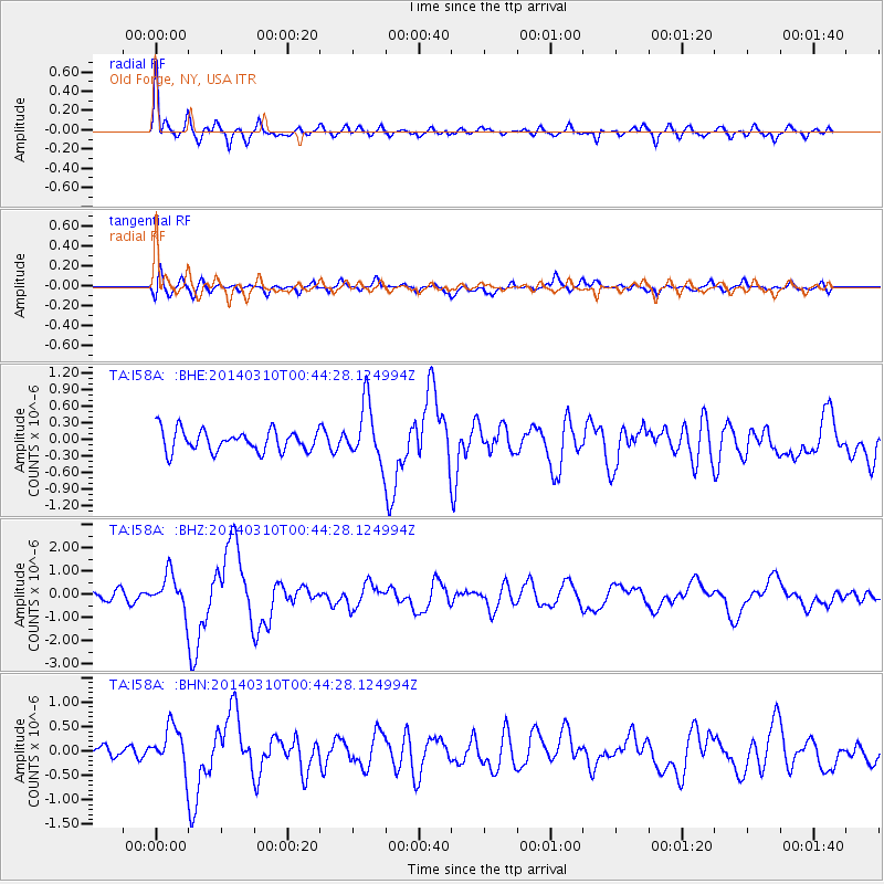
Signal To Noise
| Channel | StoN | STA | LTA |
| TA:I58A: :BHZ:20140310T00:44:28.124994Z | 3.4039118 | 7.679406E-7 | 2.2560532E-7 |
| TA:I58A: :BHN:20140310T00:44:28.124994Z | 2.1347897 | 4.3713973E-7 | 2.0476946E-7 |
| TA:I58A: :BHE:20140310T00:44:28.124994Z | 2.6634755 | 5.157419E-7 | 1.9363492E-7 |
| Arrivals |
| Ps | 1.7 SECOND |
| PpPs | 5.0 SECOND |
| PsPs/PpSs | 6.7 SECOND |


