You are here: Home > Network List > TA - USArray Transportable Network (new EarthScope stations) Stations List
> Station J54A Appleton, NY, USA > Earthquake Result Viewer
J54A Appleton, NY, USA - Earthquake Result Viewer
| Earthquake location: |
Near Coast Of Guerrero, Mexico |
| Earthquake latitude/longitude: |
16.0/-98.3 |
| Earthquake time(UTC): |
2014/03/10 (069) 00:38:15 GMT |
| Earthquake Depth: |
8.4 km |
| Earthquake Magnitude: |
5.8 MWW, 5.9 MWC, 6.0 MWB |
| Earthquake Catalog/Contributor: |
NEIC PDE/NEIC COMCAT |
|
| Network: |
TA USArray Transportable Network (new EarthScope stations) |
| Station: |
J54A Appleton, NY, USA |
| Lat/Lon: |
43.27 N/78.64 W |
| Elevation: |
112 m |
|
| Distance: |
31.9 deg |
| Az: |
27.749 deg |
| Baz: |
217.803 deg |
| Ray Param: |
0.07887543 |
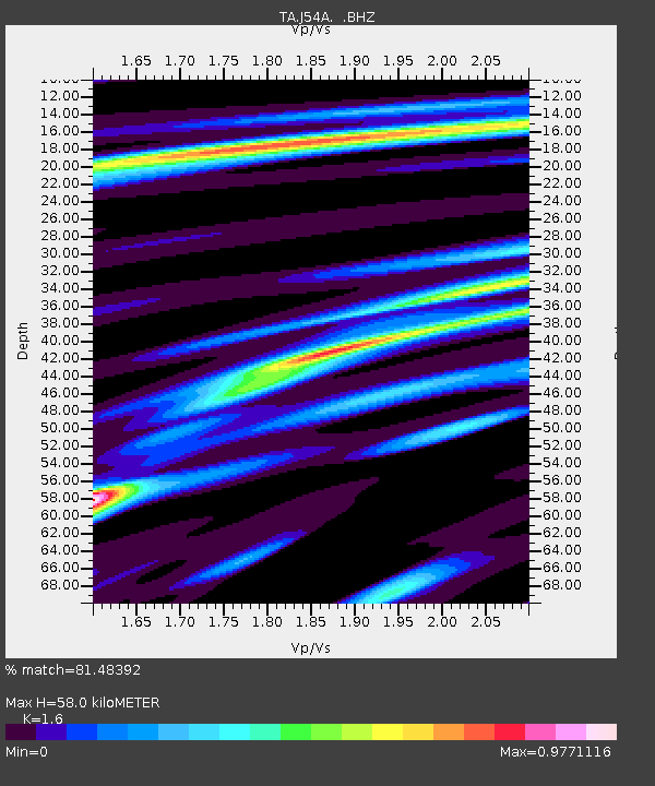
| Estimated Moho Depth: |
58.0 km |
| Estimated Crust Vp/Vs: |
1.60 |
| Assumed Crust Vp: |
6.419 km/s |
| Estimated Crust Vs: |
4.012 km/s |
| Estimated Crust Poisson's Ratio: |
0.18 |
|
| Radial Match: |
81.48392 % |
| Radial Bump: |
400 |
| Transverse Match: |
56.488377 % |
| Transverse Bump: |
400 |
| SOD ConfigId: |
626651 |
| Insert Time: |
2014-04-21 02:50:25.394 +0000 |
| GWidth: |
2.5 |
| Max Bumps: |
400 |
| Tol: |
0.001 |
|
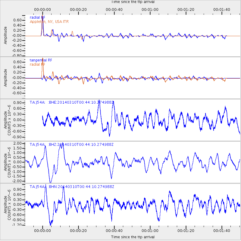
Signal To Noise
| Channel | StoN | STA | LTA |
| TA:J54A: :BHZ:20140310T00:44:10.274988Z | 6.30561 | 1.2094141E-6 | 1.917997E-7 |
| TA:J54A: :BHN:20140310T00:44:10.274988Z | 3.7490742 | 6.460751E-7 | 1.7232924E-7 |
| TA:J54A: :BHE:20140310T00:44:10.274988Z | 3.2284012 | 4.927665E-7 | 1.5263484E-7 |
| Arrivals |
| Ps | 5.9 SECOND |
| PpPs | 22 SECOND |
| PsPs/PpSs | 27 SECOND |


