You are here: Home > Network List > TA - USArray Transportable Network (new EarthScope stations) Stations List
> Station K52A Tillsonburg, ON, CAN > Earthquake Result Viewer
K52A Tillsonburg, ON, CAN - Earthquake Result Viewer

| Earthquake location: |
Near Coast Of Guerrero, Mexico |
| Earthquake latitude/longitude: |
16.0/-98.3 |
| Earthquake time(UTC): |
2014/03/10 (069) 00:38:15 GMT |
| Earthquake Depth: |
8.4 km |
| Earthquake Magnitude: |
5.8 MWW, 5.9 MWC, 6.0 MWB |
| Earthquake Catalog/Contributor: |
NEIC PDE/NEIC COMCAT |
|
| Network: |
TA USArray Transportable Network (new EarthScope stations) |
| Station: |
K52A Tillsonburg, ON, CAN |
| Lat/Lon: |
42.78 N/80.71 W |
| Elevation: |
232 m |
|
| Distance: |
30.6 deg |
| Az: |
25.949 deg |
| Baz: |
214.854 deg |
| Ray Param: |
0.07928579 |
| Estimated Moho Depth: |
52.75 km |
| Estimated Crust Vp/Vs: |
1.60 |
| Assumed Crust Vp: |
6.53 km/s |
| Estimated Crust Vs: |
4.082 km/s |
| Estimated Crust Poisson's Ratio: |
0.18 |
|
| Radial Match: |
82.88623 % |
| Radial Bump: |
400 |
| Transverse Match: |
50.978157 % |
| Transverse Bump: |
400 |
| SOD ConfigId: |
626651 |
| Insert Time: |
2014-04-21 02:50:58.213 +0000 |
| GWidth: |
2.5 |
| Max Bumps: |
400 |
| Tol: |
0.001 |
|
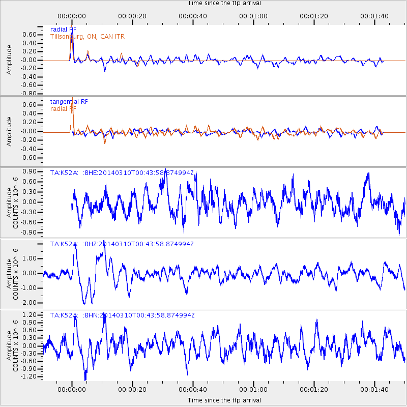
Signal To Noise
| Channel | StoN | STA | LTA |
| TA:K52A: :BHZ:20140310T00:43:58.874994Z | 5.846043 | 1.2241145E-6 | 2.0939198E-7 |
| TA:K52A: :BHN:20140310T00:43:58.874994Z | 5.1364574 | 6.758509E-7 | 1.3157918E-7 |
| TA:K52A: :BHE:20140310T00:43:58.874994Z | 2.0208638 | 5.40792E-7 | 2.6760438E-7 |
| Arrivals |
| Ps | 5.3 SECOND |
| PpPs | 19 SECOND |
| PsPs/PpSs | 24 SECOND |


