You are here: Home > Network List > TA - USArray Transportable Network (new EarthScope stations) Stations List
> Station K58A Earlville, NY, USA > Earthquake Result Viewer
K58A Earlville, NY, USA - Earthquake Result Viewer
| Earthquake location: |
Near Coast Of Guerrero, Mexico |
| Earthquake latitude/longitude: |
16.0/-98.3 |
| Earthquake time(UTC): |
2014/03/10 (069) 00:38:15 GMT |
| Earthquake Depth: |
8.4 km |
| Earthquake Magnitude: |
5.8 MWW, 5.9 MWC, 6.0 MWB |
| Earthquake Catalog/Contributor: |
NEIC PDE/NEIC COMCAT |
|
| Network: |
TA USArray Transportable Network (new EarthScope stations) |
| Station: |
K58A Earlville, NY, USA |
| Lat/Lon: |
42.76 N/75.65 W |
| Elevation: |
509 m |
|
| Distance: |
33.0 deg |
| Az: |
31.48 deg |
| Baz: |
222.986 deg |
| Ray Param: |
0.078434125 |
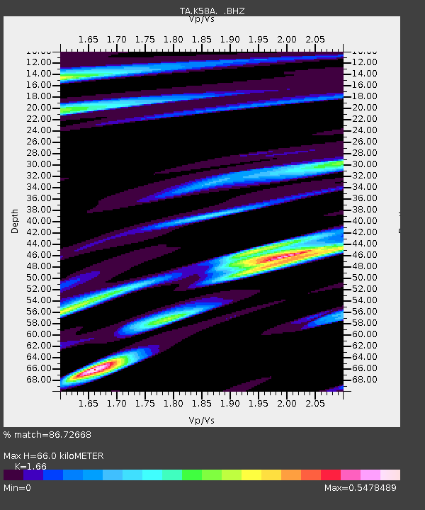
| Estimated Moho Depth: |
66.0 km |
| Estimated Crust Vp/Vs: |
1.66 |
| Assumed Crust Vp: |
6.419 km/s |
| Estimated Crust Vs: |
3.867 km/s |
| Estimated Crust Poisson's Ratio: |
0.22 |
|
| Radial Match: |
86.72668 % |
| Radial Bump: |
400 |
| Transverse Match: |
63.745083 % |
| Transverse Bump: |
400 |
| SOD ConfigId: |
626651 |
| Insert Time: |
2014-04-21 02:51:11.198 +0000 |
| GWidth: |
2.5 |
| Max Bumps: |
400 |
| Tol: |
0.001 |
|
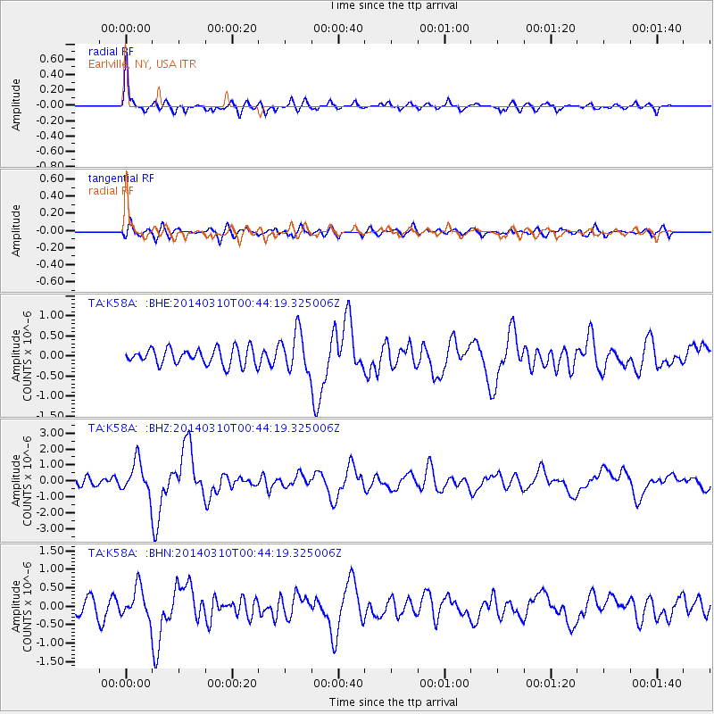
Signal To Noise
| Channel | StoN | STA | LTA |
| TA:K58A: :BHZ:20140310T00:44:19.325006Z | 4.118588 | 1.0351954E-6 | 2.513472E-7 |
| TA:K58A: :BHN:20140310T00:44:19.325006Z | 1.9373351 | 4.1812893E-7 | 2.1582684E-7 |
| TA:K58A: :BHE:20140310T00:44:19.325006Z | 2.470579 | 4.9443753E-7 | 2.0013023E-7 |
| Arrivals |
| Ps | 7.4 SECOND |
| PpPs | 25 SECOND |
| PsPs/PpSs | 33 SECOND |


