You are here: Home > Network List > TA - USArray Transportable Network (new EarthScope stations) Stations List
> Station L59A Walton, NY, USA > Earthquake Result Viewer
L59A Walton, NY, USA - Earthquake Result Viewer
| Earthquake location: |
Near Coast Of Guerrero, Mexico |
| Earthquake latitude/longitude: |
16.0/-98.3 |
| Earthquake time(UTC): |
2014/03/10 (069) 00:38:15 GMT |
| Earthquake Depth: |
8.4 km |
| Earthquake Magnitude: |
5.8 MWW, 5.9 MWC, 6.0 MWB |
| Earthquake Catalog/Contributor: |
NEIC PDE/NEIC COMCAT |
|
| Network: |
TA USArray Transportable Network (new EarthScope stations) |
| Station: |
L59A Walton, NY, USA |
| Lat/Lon: |
42.19 N/75.04 W |
| Elevation: |
677 m |
|
| Distance: |
32.8 deg |
| Az: |
32.804 deg |
| Baz: |
224.505 deg |
| Ray Param: |
0.0784798 |
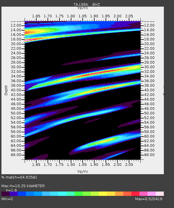
| Estimated Moho Depth: |
18.25 km |
| Estimated Crust Vp/Vs: |
1.60 |
| Assumed Crust Vp: |
6.419 km/s |
| Estimated Crust Vs: |
4.012 km/s |
| Estimated Crust Poisson's Ratio: |
0.18 |
|
| Radial Match: |
84.92561 % |
| Radial Bump: |
318 |
| Transverse Match: |
69.63662 % |
| Transverse Bump: |
400 |
| SOD ConfigId: |
626651 |
| Insert Time: |
2014-04-21 02:51:40.503 +0000 |
| GWidth: |
2.5 |
| Max Bumps: |
400 |
| Tol: |
0.001 |
|
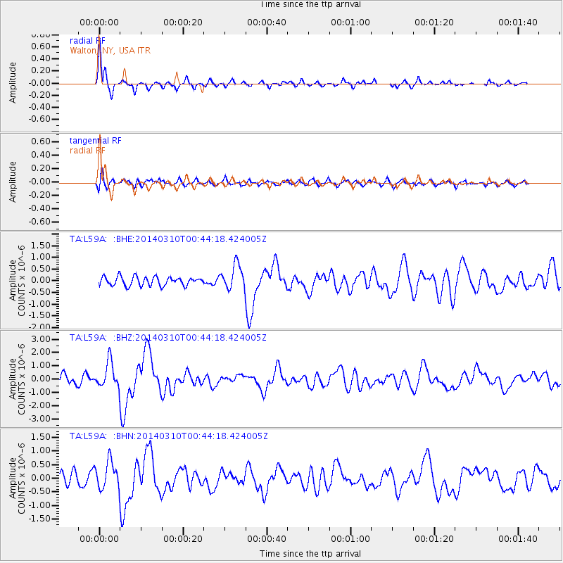
Signal To Noise
| Channel | StoN | STA | LTA |
| TA:L59A: :BHZ:20140310T00:44:18.424005Z | 2.93281 | 1.0039181E-6 | 3.4230587E-7 |
| TA:L59A: :BHN:20140310T00:44:18.424005Z | 2.4337687 | 5.097445E-7 | 2.0944657E-7 |
| TA:L59A: :BHE:20140310T00:44:18.424005Z | 2.9233093 | 5.408145E-7 | 1.8500077E-7 |
| Arrivals |
| Ps | 1.9 SECOND |
| PpPs | 6.8 SECOND |
| PsPs/PpSs | 8.6 SECOND |


