You are here: Home > Network List > TA - USArray Transportable Network (new EarthScope stations) Stations List
> Station M56A Emporium, PA, USA > Earthquake Result Viewer
M56A Emporium, PA, USA - Earthquake Result Viewer
| Earthquake location: |
Near Coast Of Guerrero, Mexico |
| Earthquake latitude/longitude: |
16.0/-98.3 |
| Earthquake time(UTC): |
2014/03/10 (069) 00:38:15 GMT |
| Earthquake Depth: |
8.4 km |
| Earthquake Magnitude: |
5.8 MWW, 5.9 MWC, 6.0 MWB |
| Earthquake Catalog/Contributor: |
NEIC PDE/NEIC COMCAT |
|
| Network: |
TA USArray Transportable Network (new EarthScope stations) |
| Station: |
M56A Emporium, PA, USA |
| Lat/Lon: |
41.48 N/78.18 W |
| Elevation: |
493 m |
|
| Distance: |
30.7 deg |
| Az: |
30.422 deg |
| Baz: |
220.393 deg |
| Ray Param: |
0.0792534 |
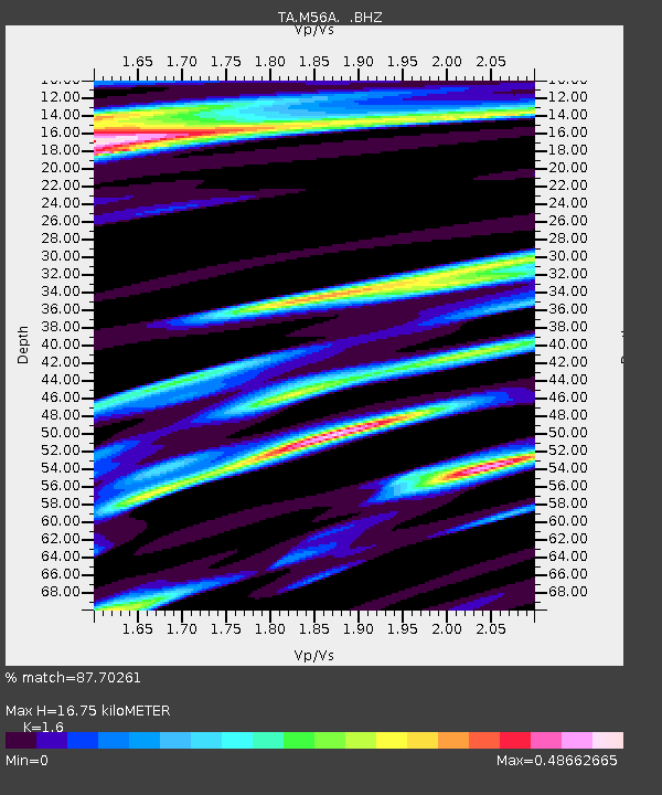
| Estimated Moho Depth: |
16.75 km |
| Estimated Crust Vp/Vs: |
1.60 |
| Assumed Crust Vp: |
6.121 km/s |
| Estimated Crust Vs: |
3.825 km/s |
| Estimated Crust Poisson's Ratio: |
0.18 |
|
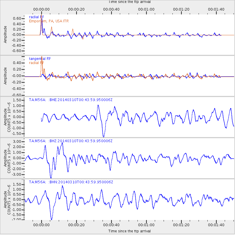
| Radial Match: |
87.70261 % |
| Radial Bump: |
397 |
| Transverse Match: |
50.911766 % |
| Transverse Bump: |
400 |
| SOD ConfigId: |
626651 |
| Insert Time: |
2014-04-21 02:52:07.534 +0000 |
| GWidth: |
2.5 |
| Max Bumps: |
400 |
| Tol: |
0.001 |
|
Signal To Noise
| Channel | StoN | STA | LTA |
| TA:M56A: :BHZ:20140310T00:43:59.950006Z | 3.9100027 | 1.1012626E-6 | 2.8165266E-7 |
| TA:M56A: :BHN:20140310T00:43:59.950006Z | 2.9845874 | 4.7151792E-7 | 1.5798429E-7 |
| TA:M56A: :BHE:20140310T00:43:59.950006Z | 2.6485958 | 5.024885E-7 | 1.8971883E-7 |
| Arrivals |
| Ps | 1.8 SECOND |
| PpPs | 6.6 SECOND |
| PsPs/PpSs | 8.3 SECOND |


