You are here: Home > Network List > TA - USArray Transportable Network (new EarthScope stations) Stations List
> Station O59A Robesonia, PA, USA > Earthquake Result Viewer
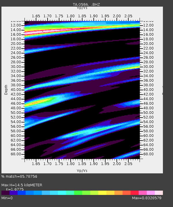
O59A Robesonia, PA, USA - Earthquake Result Viewer
| Earthquake location: |
Near Coast Of Guerrero, Mexico |
| Earthquake latitude/longitude: |
16.0/-98.3 |
| Earthquake time(UTC): |
2014/03/10 (069) 00:38:15 GMT |
| Earthquake Depth: |
8.4 km |
| Earthquake Magnitude: |
5.8 MWW, 5.9 MWC, 6.0 MWB |
| Earthquake Catalog/Contributor: |
NEIC PDE/NEIC COMCAT |
|
| Network: |
TA USArray Transportable Network (new EarthScope stations) |
| Station: |
O59A Robesonia, PA, USA |
| Lat/Lon: |
40.31 N/76.19 W |
| Elevation: |
334 m |
|
| Distance: |
30.9 deg |
| Az: |
34.143 deg |
| Baz: |
224.892 deg |
| Ray Param: |
0.0792103 |
| Estimated Moho Depth: |
14.5 km |
| Estimated Crust Vp/Vs: |
1.68 |
| Assumed Crust Vp: |
6.121 km/s |
| Estimated Crust Vs: |
3.649 km/s |
| Estimated Crust Poisson's Ratio: |
0.22 |
|
| Radial Match: |
85.78756 % |
| Radial Bump: |
350 |
| Transverse Match: |
35.082863 % |
| Transverse Bump: |
400 |
| SOD ConfigId: |
626651 |
| Insert Time: |
2014-04-21 02:52:59.329 +0000 |
| GWidth: |
2.5 |
| Max Bumps: |
400 |
| Tol: |
0.001 |
|

Signal To Noise
| Channel | StoN | STA | LTA |
| TA:O59A: :BHZ:20140310T00:44:01.399988Z | 5.1979747 | 9.053561E-7 | 1.7417477E-7 |
| TA:O59A: :BHN:20140310T00:44:01.399988Z | 1.936545 | 4.7342283E-7 | 2.4446777E-7 |
| TA:O59A: :BHE:20140310T00:44:01.399988Z | 2.4797544 | 2.7212576E-7 | 1.09739E-7 |
| Arrivals |
| Ps | 1.7 SECOND |
| PpPs | 5.9 SECOND |
| PsPs/PpSs | 7.6 SECOND |


