You are here: Home > Network List > US - United States National Seismic Network Stations List
> Station DGMT Dagmar, Montana, USA > Earthquake Result Viewer
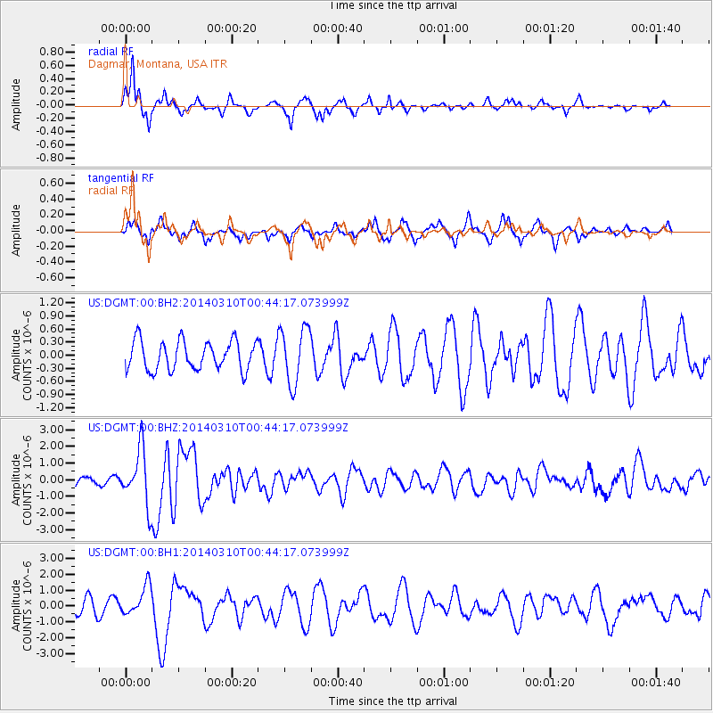
DGMT Dagmar, Montana, USA - Earthquake Result Viewer
*The percent match for this event was below the threshold and hence no stack was calculated.
| Earthquake location: |
Near Coast Of Guerrero, Mexico |
| Earthquake latitude/longitude: |
16.0/-98.3 |
| Earthquake time(UTC): |
2014/03/10 (069) 00:38:15 GMT |
| Earthquake Depth: |
8.4 km |
| Earthquake Magnitude: |
5.8 MWW, 5.9 MWC, 6.0 MWB |
| Earthquake Catalog/Contributor: |
NEIC PDE/NEIC COMCAT |
|
| Network: |
US United States National Seismic Network |
| Station: |
DGMT Dagmar, Montana, USA |
| Lat/Lon: |
48.47 N/104.20 W |
| Elevation: |
0.0 m |
|
| Distance: |
32.7 deg |
| Az: |
352.775 deg |
| Baz: |
169.53 deg |
| Ray Param: |
$rayparam |
*The percent match for this event was below the threshold and hence was not used in the summary stack. |
|
| Radial Match: |
81.352554 % |
| Radial Bump: |
308 |
| Transverse Match: |
59.332623 % |
| Transverse Bump: |
366 |
| SOD ConfigId: |
626651 |
| Insert Time: |
2014-04-21 02:53:42.360 +0000 |
| GWidth: |
2.5 |
| Max Bumps: |
400 |
| Tol: |
0.001 |
|
Signal To Noise
| Channel | StoN | STA | LTA |
| US:DGMT:00:BHZ:20140310T00:44:17.073999Z | 7.658651 | 1.6748438E-6 | 2.1868652E-7 |
| US:DGMT:00:BH1:20140310T00:44:17.073999Z | 2.3475091 | 9.590557E-7 | 4.085418E-7 |
| US:DGMT:00:BH2:20140310T00:44:17.073999Z | 1.9370914 | 6.444611E-7 | 3.3269527E-7 |
| Arrivals |
| Ps | |
| PpPs | |
| PsPs/PpSs | |


