You are here: Home > Network List > US - United States National Seismic Network Stations List
> Station MSO Missoula, Montana, USA > Earthquake Result Viewer
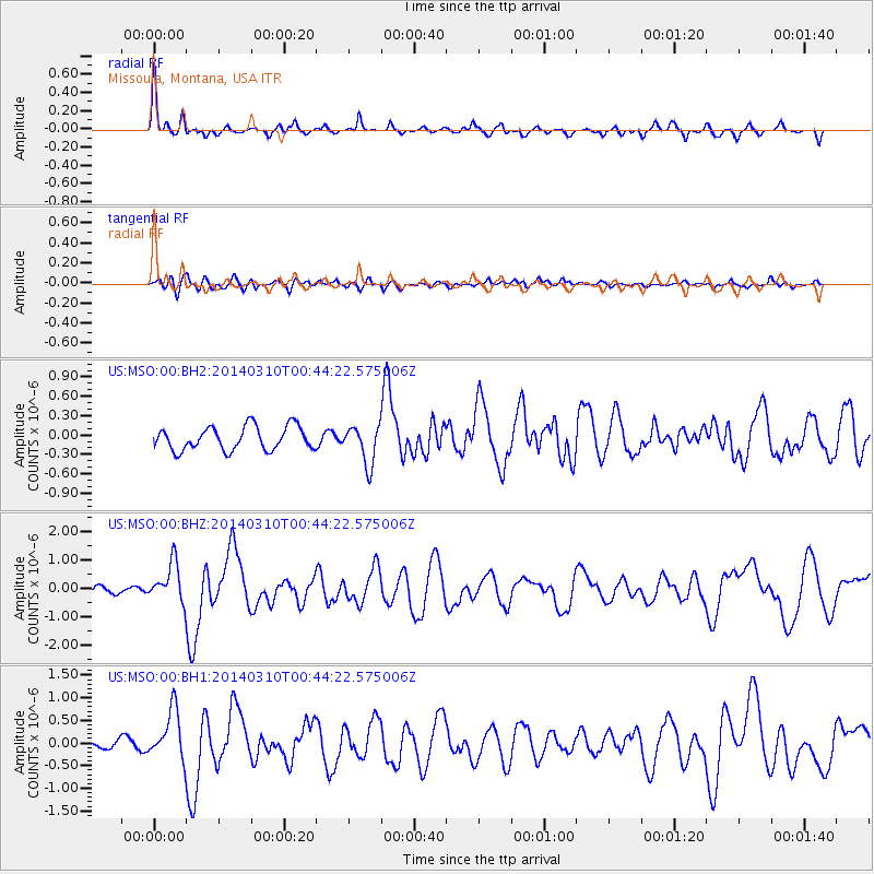
MSO Missoula, Montana, USA - Earthquake Result Viewer
*The percent match for this event was below the threshold and hence no stack was calculated.
| Earthquake location: |
Near Coast Of Guerrero, Mexico |
| Earthquake latitude/longitude: |
16.0/-98.3 |
| Earthquake time(UTC): |
2014/03/10 (069) 00:38:15 GMT |
| Earthquake Depth: |
8.4 km |
| Earthquake Magnitude: |
5.8 MWW, 5.9 MWC, 6.0 MWB |
| Earthquake Catalog/Contributor: |
NEIC PDE/NEIC COMCAT |
|
| Network: |
US United States National Seismic Network |
| Station: |
MSO Missoula, Montana, USA |
| Lat/Lon: |
46.83 N/113.94 W |
| Elevation: |
1264 m |
|
| Distance: |
33.3 deg |
| Az: |
340.357 deg |
| Baz: |
151.916 deg |
| Ray Param: |
$rayparam |
*The percent match for this event was below the threshold and hence was not used in the summary stack. |
|
| Radial Match: |
76.52099 % |
| Radial Bump: |
369 |
| Transverse Match: |
45.510517 % |
| Transverse Bump: |
400 |
| SOD ConfigId: |
626651 |
| Insert Time: |
2014-04-21 02:54:07.651 +0000 |
| GWidth: |
2.5 |
| Max Bumps: |
400 |
| Tol: |
0.001 |
|
Signal To Noise
| Channel | StoN | STA | LTA |
| US:MSO:00:BHZ:20140310T00:44:22.575006Z | 6.048992 | 6.7694793E-7 | 1.1191086E-7 |
| US:MSO:00:BH1:20140310T00:44:22.575006Z | 3.6552842 | 5.4529016E-7 | 1.491786E-7 |
| US:MSO:00:BH2:20140310T00:44:22.575006Z | 1.6536908 | 2.9878197E-7 | 1.8067583E-7 |
| Arrivals |
| Ps | |
| PpPs | |
| PsPs/PpSs | |


