You are here: Home > Network List > WY - Yellowstone Wyoming Seismic Network Stations List
> Station YMR Madison River, YNP, WY, USA > Earthquake Result Viewer
YMR Madison River, YNP, WY, USA - Earthquake Result Viewer
| Earthquake location: |
Near Coast Of Guerrero, Mexico |
| Earthquake latitude/longitude: |
16.0/-98.3 |
| Earthquake time(UTC): |
2014/03/10 (069) 00:38:15 GMT |
| Earthquake Depth: |
8.4 km |
| Earthquake Magnitude: |
5.8 MWW, 5.9 MWC, 6.0 MWB |
| Earthquake Catalog/Contributor: |
NEIC PDE/NEIC COMCAT |
|
| Network: |
WY Yellowstone Wyoming Seismic Network |
| Station: |
YMR Madison River, YNP, WY, USA |
| Lat/Lon: |
44.67 N/110.96 W |
| Elevation: |
2149 m |
|
| Distance: |
30.5 deg |
| Az: |
342.081 deg |
| Baz: |
155.505 deg |
| Ray Param: |
0.07932609 |
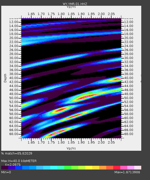
| Estimated Moho Depth: |
40.0 km |
| Estimated Crust Vp/Vs: |
2.10 |
| Assumed Crust Vp: |
6.35 km/s |
| Estimated Crust Vs: |
3.027 km/s |
| Estimated Crust Poisson's Ratio: |
0.35 |
|
| Radial Match: |
85.82029 % |
| Radial Bump: |
400 |
| Transverse Match: |
73.531425 % |
| Transverse Bump: |
400 |
| SOD ConfigId: |
626651 |
| Insert Time: |
2014-04-21 02:56:53.304 +0000 |
| GWidth: |
2.5 |
| Max Bumps: |
400 |
| Tol: |
0.001 |
|

Signal To Noise
| Channel | StoN | STA | LTA |
| WY:YMR:01:HHZ:20140310T00:43:57.50799Z | 7.645942 | 2.566796E-8 | 3.3570697E-9 |
| WY:YMR:01:HHN:20140310T00:43:57.50799Z | 4.1232104 | 1.882903E-8 | 4.5665947E-9 |
| WY:YMR:01:HHE:20140310T00:43:57.50799Z | 2.0111573 | 1.0358919E-8 | 5.150725E-9 |
| Arrivals |
| Ps | 7.4 SECOND |
| PpPs | 18 SECOND |
| PsPs/PpSs | 26 SECOND |


