You are here: Home > Network List > WY - Yellowstone Wyoming Seismic Network Stations List
> Station YUF Upper Falls, WY, USA > Earthquake Result Viewer
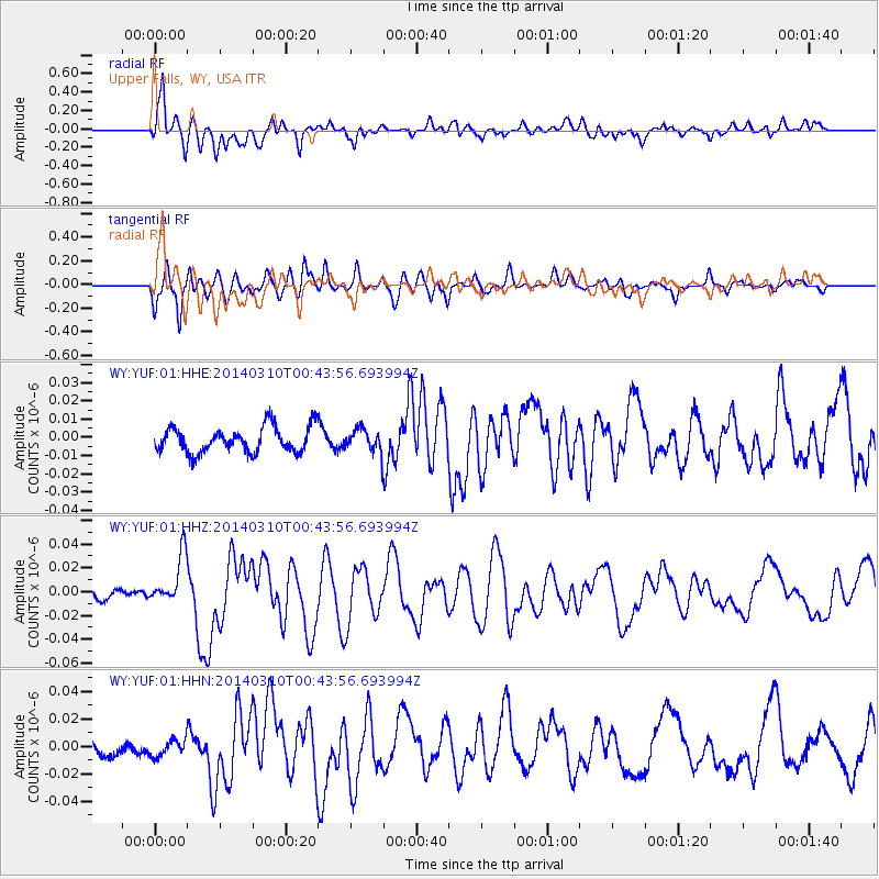
YUF Upper Falls, WY, USA - Earthquake Result Viewer
*The percent match for this event was below the threshold and hence no stack was calculated.
| Earthquake location: |
Near Coast Of Guerrero, Mexico |
| Earthquake latitude/longitude: |
16.0/-98.3 |
| Earthquake time(UTC): |
2014/03/10 (069) 00:38:15 GMT |
| Earthquake Depth: |
8.4 km |
| Earthquake Magnitude: |
5.8 MWW, 5.9 MWC, 6.0 MWB |
| Earthquake Catalog/Contributor: |
NEIC PDE/NEIC COMCAT |
|
| Network: |
WY Yellowstone Wyoming Seismic Network |
| Station: |
YUF Upper Falls, WY, USA |
| Lat/Lon: |
44.71 N/110.51 W |
| Elevation: |
2394 m |
|
| Distance: |
30.4 deg |
| Az: |
342.699 deg |
| Baz: |
156.356 deg |
| Ray Param: |
$rayparam |
*The percent match for this event was below the threshold and hence was not used in the summary stack. |
|
| Radial Match: |
79.456505 % |
| Radial Bump: |
400 |
| Transverse Match: |
70.735855 % |
| Transverse Bump: |
400 |
| SOD ConfigId: |
626651 |
| Insert Time: |
2014-04-21 02:57:06.404 +0000 |
| GWidth: |
2.5 |
| Max Bumps: |
400 |
| Tol: |
0.001 |
|
Signal To Noise
| Channel | StoN | STA | LTA |
| WY:YUF:01:HHZ:20140310T00:43:56.693994Z | 3.827734 | 2.0719577E-8 | 5.4130136E-9 |
| WY:YUF:01:HHN:20140310T00:43:56.693994Z | 1.3507712 | 6.532202E-9 | 4.835906E-9 |
| WY:YUF:01:HHE:20140310T00:43:56.693994Z | 0.9234222 | 6.5015553E-9 | 7.040718E-9 |
| Arrivals |
| Ps | |
| PpPs | |
| PsPs/PpSs | |


