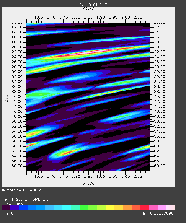
URI Uribia, Guajira, Columbia - Earthquake Result Viewer

Earthquake location: Off Coast Of Northern California
Earthquake latitude/longitude: 40.8/-125.1
Earthquake time(UTC): 2014/03/10 (069) 05:18:13 GMT
Earthquake Depth: 17 km
Earthquake Magnitude: 6.8 MW, 6.8 MWR, 6.9 MWW, 6.9 MWB, 7.0 MI, 7.0 MWC
Earthquake Catalog/Contributor: NEIC PDE/NEIC COMCAT
Network: CM Red Sismologica Nacional de Columbia
Station: URI Uribia, Guajira, Columbia
Lat/Lon: 11.70 N/71.99 W
Elevation: 68 m
Distance: 54.8 deg
Az: 106.338 deg
Baz: 311.975 deg
Ray Param: 0.06523018
Estimated Moho Depth: 21.75 km
Estimated Crust Vp/Vs: 1.87
Assumed Crust Vp: 5.738 km/s
Estimated Crust Vs: 3.077 km/s
Estimated Crust Poisson's Ratio: 0.30
Radial Match: 95.749855 %
Radial Bump: 400
Transverse Match: 88.15368 %
Transverse Bump: 400
SOD ConfigId: 626651
Insert Time: 2014-04-21 02:58:17.364 +0000
GWidth: 2.5
Max Bumps: 400
Tol: 0.001

Signal To Noise

ChannelStoNSTALTA
CM:URI:01:BHZ:20140310T05:27:11.032996Z10.4882641.1289942E-61.0764357E-7
CM:URI:01:BHN:20140310T05:27:11.032996Z5.6184373.5649143E-76.345029E-8
CM:URI:01:BHE:20140310T05:27:11.032996Z3.6995342.9521544E-77.979801E-8
Arrivals
Ps3.4 SECOND
PpPs10 SECOND
PsPs/PpSs14 SECOND