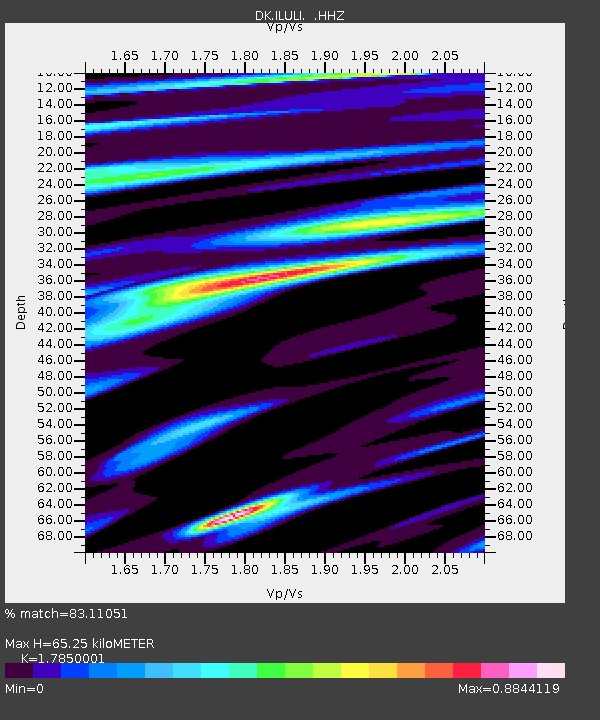
ILULI Ilulissat, Greenland - Earthquake Result Viewer

Earthquake location: Off Coast Of Northern California
Earthquake latitude/longitude: 40.8/-125.1
Earthquake time(UTC): 2014/03/10 (069) 05:18:13 GMT
Earthquake Depth: 17 km
Earthquake Magnitude: 6.8 MW, 6.8 MWR, 6.9 MWW, 6.9 MWB, 7.0 MI, 7.0 MWC
Earthquake Catalog/Contributor: NEIC PDE/NEIC COMCAT
Network: DK Danish Seismological Network
Station: ILULI Ilulissat, Greenland
Lat/Lon: 69.21 N/51.10 W
Elevation: 54 m
Distance: 46.9 deg
Az: 28.024 deg
Baz: 272.94 deg
Ray Param: 0.070311256
Estimated Moho Depth: 65.25 km
Estimated Crust Vp/Vs: 1.79
Assumed Crust Vp: 6.459 km/s
Estimated Crust Vs: 3.619 km/s
Estimated Crust Poisson's Ratio: 0.27
Radial Match: 83.11051 %
Radial Bump: 309
Transverse Match: 72.43673 %
Transverse Bump: 398
SOD ConfigId: 626651
Insert Time: 2014-04-21 02:59:55.949 +0000
GWidth: 2.5
Max Bumps: 400
Tol: 0.001

Signal To Noise

ChannelStoNSTALTA
DK:ILULI: :HHZ:20140310T05:26:12.150Z2.40299271.4932214E-66.214007E-7
DK:ILULI: :HHN:20140310T05:26:12.150Z0.93355655.089225E-75.4514373E-7
DK:ILULI: :HHE:20140310T05:26:12.150Z1.655797.880878E-74.7595879E-7
Arrivals
Ps8.4 SECOND
PpPs26 SECOND
PsPs/PpSs35 SECOND