You are here: Home > Network List > CI - Caltech Regional Seismic Network Stations List
> Station CIA CIA, Avalon Catalina Island, CA, USA > Earthquake Result Viewer
CIA CIA, Avalon Catalina Island, CA, USA - Earthquake Result Viewer
| Earthquake location: |
Northern Peru |
| Earthquake latitude/longitude: |
-5.7/-76.4 |
| Earthquake time(UTC): |
2005/09/26 (269) 01:55:37 GMT |
| Earthquake Depth: |
115 km |
| Earthquake Magnitude: |
6.7 MB, 7.5 MW, 7.5 MW |
| Earthquake Catalog/Contributor: |
WHDF/NEIC |
|
| Network: |
CI Caltech Regional Seismic Network |
| Station: |
CIA CIA, Avalon Catalina Island, CA, USA |
| Lat/Lon: |
33.40 N/118.41 W |
| Elevation: |
467 m |
|
| Distance: |
55.6 deg |
| Az: |
317.281 deg |
| Baz: |
126.19 deg |
| Ray Param: |
0.06431722 |
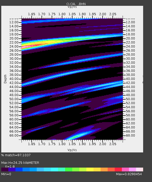
| Estimated Moho Depth: |
24.25 km |
| Estimated Crust Vp/Vs: |
1.60 |
| Assumed Crust Vp: |
6.048 km/s |
| Estimated Crust Vs: |
3.78 km/s |
| Estimated Crust Poisson's Ratio: |
0.18 |
|
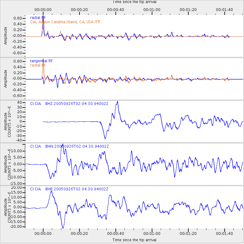
| Radial Match: |
97.1037 % |
| Radial Bump: |
400 |
| Transverse Match: |
86.701775 % |
| Transverse Bump: |
400 |
| SOD ConfigId: |
2564 |
| Insert Time: |
2010-02-25 20:58:00.876 +0000 |
| GWidth: |
2.5 |
| Max Bumps: |
400 |
| Tol: |
0.001 |
|
Signal To Noise
| Channel | StoN | STA | LTA |
| CI:CIA: :BHN:20050926T02:04:30.94002Z | 24.328194 | 5.2508767E-6 | 2.1583503E-7 |
| CI:CIA: :BHE:20050926T02:04:30.94002Z | 27.971504 | 7.944022E-6 | 2.840041E-7 |
| CI:CIA: :BHZ:20050926T02:04:30.94002Z | 50.638176 | 1.7020799E-5 | 3.3612582E-7 |
| Arrivals |
| Ps | 2.5 SECOND |
| PpPs | 9.9 SECOND |
| PsPs/PpSs | 12 SECOND |


