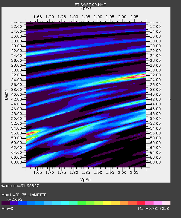
SWET Sewanee,TN - Earthquake Result Viewer

Earthquake location: Off Coast Of Northern California
Earthquake latitude/longitude: 40.8/-125.1
Earthquake time(UTC): 2014/03/10 (069) 05:18:13 GMT
Earthquake Depth: 17 km
Earthquake Magnitude: 6.8 MW, 6.8 MWR, 6.9 MWW, 6.9 MWB, 7.0 MI, 7.0 MWC
Earthquake Catalog/Contributor: NEIC PDE/NEIC COMCAT
Network: ET CERI Southern Appalachian seismic Network
Station: SWET Sewanee,TN
Lat/Lon: 35.22 N/85.93 W
Elevation: 581 m
Distance: 31.2 deg
Az: 87.524 deg
Baz: 292.196 deg
Ray Param: 0.07912407
Estimated Moho Depth: 31.75 km
Estimated Crust Vp/Vs: 2.10
Assumed Crust Vp: 6.35 km/s
Estimated Crust Vs: 3.031 km/s
Estimated Crust Poisson's Ratio: 0.35
Radial Match: 91.98527 %
Radial Bump: 234
Transverse Match: 72.723076 %
Transverse Bump: 400
SOD ConfigId: 626651
Insert Time: 2014-04-21 03:00:20.844 +0000
GWidth: 2.5
Max Bumps: 400
Tol: 0.001

Signal To Noise

ChannelStoNSTALTA
ET:SWET:00:HHZ:20140310T05:24:01.040015Z31.8266743.712533E-61.1664848E-7
ET:SWET:00:HHN:20140310T05:24:01.040015Z11.3957741.060582E-69.306801E-8
ET:SWET:00:HHE:20140310T05:24:01.040015Z18.8849051.8502524E-69.79752E-8
Arrivals
Ps5.8 SECOND
PpPs14 SECOND
PsPs/PpSs20 SECOND