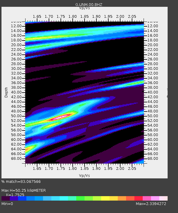
UNM Unam,Mexico - Earthquake Result Viewer

Earthquake location: Off Coast Of Northern California
Earthquake latitude/longitude: 40.8/-125.1
Earthquake time(UTC): 2014/03/10 (069) 05:18:13 GMT
Earthquake Depth: 17 km
Earthquake Magnitude: 6.8 MW, 6.8 MWR, 6.9 MWW, 6.9 MWB, 7.0 MI, 7.0 MWC
Earthquake Catalog/Contributor: NEIC PDE/NEIC COMCAT
Network: G GEOSCOPE
Station: UNM Unam,Mexico
Lat/Lon: 19.33 N/99.18 W
Elevation: 2280 m
Distance: 30.8 deg
Az: 126.274 deg
Baz: 319.621 deg
Ray Param: 0.07921795
Estimated Moho Depth: 50.25 km
Estimated Crust Vp/Vs: 1.75
Assumed Crust Vp: 6.597 km/s
Estimated Crust Vs: 3.765 km/s
Estimated Crust Poisson's Ratio: 0.26
Radial Match: 83.067566 %
Radial Bump: 396
Transverse Match: 64.68587 %
Transverse Bump: 400
SOD ConfigId: 626651
Insert Time: 2014-04-21 03:00:38.449 +0000
GWidth: 2.5
Max Bumps: 400
Tol: 0.001

Signal To Noise

ChannelStoNSTALTA
G:UNM:00:BHZ:20140310T05:23:57.898993Z2.61356831.1504106E-64.4016858E-7
G:UNM:00:BHN:20140310T05:23:57.898993Z0.98057174.3266687E-74.412394E-7
G:UNM:00:BHE:20140310T05:23:57.898993Z1.44431524.4645373E-73.0911102E-7
Arrivals
Ps6.2 SECOND
PpPs19 SECOND
PsPs/PpSs25 SECOND