You are here: Home > Network List > CI - Caltech Regional Seismic Network Stations List
> Station MPM Manuel Prospect Mine, California, USA > Earthquake Result Viewer
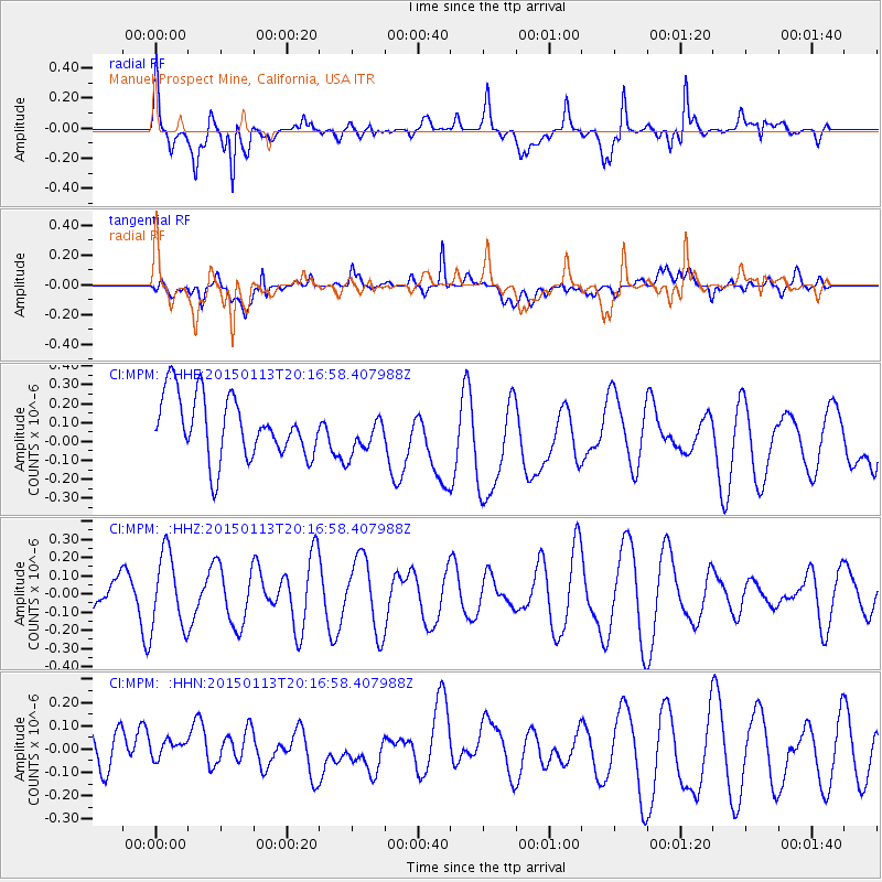
MPM Manuel Prospect Mine, California, USA - Earthquake Result Viewer
*The percent match for this event was below the threshold and hence no stack was calculated.
| Earthquake location: |
Eastern New Guinea Reg., P.N.G. |
| Earthquake latitude/longitude: |
-6.4/147.1 |
| Earthquake time(UTC): |
2015/01/13 (013) 20:03:58 GMT |
| Earthquake Depth: |
46 km |
| Earthquake Magnitude: |
5.0 MW, 5.2 mb, 4.3 MS |
| Earthquake Catalog/Contributor: |
ISC/ISC |
|
| Network: |
CI Caltech Regional Seismic Network |
| Station: |
MPM Manuel Prospect Mine, California, USA |
| Lat/Lon: |
36.06 N/117.49 W |
| Elevation: |
185 m |
|
| Distance: |
98.1 deg |
| Az: |
54.567 deg |
| Baz: |
268.008 deg |
| Ray Param: |
$rayparam |
*The percent match for this event was below the threshold and hence was not used in the summary stack. |
|
| Radial Match: |
57.56687 % |
| Radial Bump: |
400 |
| Transverse Match: |
67.69272 % |
| Transverse Bump: |
400 |
| SOD ConfigId: |
3390531 |
| Insert Time: |
2019-04-16 01:04:44.455 +0000 |
| GWidth: |
2.5 |
| Max Bumps: |
400 |
| Tol: |
0.001 |
|
Signal To Noise
| Channel | StoN | STA | LTA |
| CI:MPM: :HHZ:20150113T20:16:58.407988Z | 3.30736 | 2.0830589E-7 | 6.298253E-8 |
| CI:MPM: :HHN:20150113T20:16:58.407988Z | 0.69988143 | 6.397072E-8 | 9.140222E-8 |
| CI:MPM: :HHE:20150113T20:16:58.407988Z | 0.6487993 | 1.05759675E-7 | 1.6300831E-7 |
| Arrivals |
| Ps | |
| PpPs | |
| PsPs/PpSs | |


