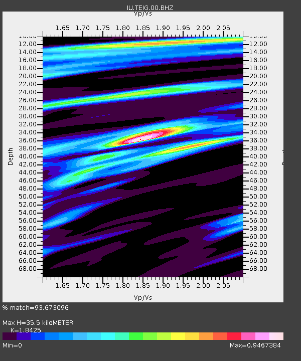
TEIG Tepich, Yucatan, Mexico - Earthquake Result Viewer

Earthquake location: Off Coast Of Northern California
Earthquake latitude/longitude: 40.8/-125.1
Earthquake time(UTC): 2014/03/10 (069) 05:18:13 GMT
Earthquake Depth: 17 km
Earthquake Magnitude: 6.8 MW, 6.8 MWR, 6.9 MWW, 6.9 MWB, 7.0 MI, 7.0 MWC
Earthquake Catalog/Contributor: NEIC PDE/NEIC COMCAT
Network: IU Global Seismograph Network (GSN - IRIS/USGS)
Station: TEIG Tepich, Yucatan, Mexico
Lat/Lon: 20.23 N/88.28 W
Elevation: 40 m
Distance: 37.4 deg
Az: 112.086 deg
Baz: 311.516 deg
Ray Param: 0.07612026
Estimated Moho Depth: 35.5 km
Estimated Crust Vp/Vs: 1.84
Assumed Crust Vp: 5.817 km/s
Estimated Crust Vs: 3.157 km/s
Estimated Crust Poisson's Ratio: 0.29
Radial Match: 93.673096 %
Radial Bump: 318
Transverse Match: 47.18955 %
Transverse Bump: 400
SOD ConfigId: 626651
Insert Time: 2014-04-21 03:03:18.858 +0000
GWidth: 2.5
Max Bumps: 400
Tol: 0.001

Signal To Noise

ChannelStoNSTALTA
IU:TEIG:00:BHZ:20140310T05:24:54.91001Z16.9703922.94918E-61.7378385E-7
IU:TEIG:00:BH1:20140310T05:24:54.91001Z0.404849684.8137526E-81.18902214E-7
IU:TEIG:00:BH2:20140310T05:24:54.91001Z6.49352361.8136078E-62.7929488E-7
Arrivals
Ps5.4 SECOND
PpPs16 SECOND
PsPs/PpSs22 SECOND