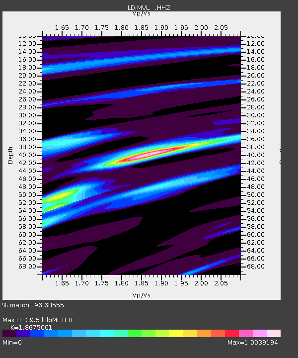
MVL Millersville University, PA - Earthquake Result Viewer

Earthquake location: Off Coast Of Northern California
Earthquake latitude/longitude: 40.8/-125.1
Earthquake time(UTC): 2014/03/10 (069) 05:18:13 GMT
Earthquake Depth: 17 km
Earthquake Magnitude: 6.8 MW, 6.8 MWR, 6.9 MWW, 6.9 MWB, 7.0 MI, 7.0 MWC
Earthquake Catalog/Contributor: NEIC PDE/NEIC COMCAT
Network: LD Lamont-Doherty Cooperative Seismographic Network
Station: MVL Millersville University, PA
Lat/Lon: 40.00 N/76.35 W
Elevation: 91 m
Distance: 36.8 deg
Az: 74.875 deg
Baz: 287.518 deg
Ray Param: 0.07648491
Estimated Moho Depth: 39.5 km
Estimated Crust Vp/Vs: 1.87
Assumed Crust Vp: 6.419 km/s
Estimated Crust Vs: 3.437 km/s
Estimated Crust Poisson's Ratio: 0.30
Radial Match: 96.68555 %
Radial Bump: 212
Transverse Match: 88.76991 %
Transverse Bump: 400
SOD ConfigId: 626651
Insert Time: 2014-04-21 03:04:46.605 +0000
GWidth: 2.5
Max Bumps: 400
Tol: 0.001

Signal To Noise

ChannelStoNSTALTA
LD:MVL: :HHZ:20140310T05:24:49.229987Z10.9340742.4309222E-62.2232537E-7
LD:MVL: :HHN:20140310T05:24:49.229987Z7.0512989.608658E-71.3626793E-7
LD:MVL: :HHE:20140310T05:24:49.229987Z9.78037551.5588001E-61.593804E-7
Arrivals
Ps5.7 SECOND
PpPs16 SECOND
PsPs/PpSs22 SECOND