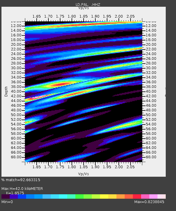
PAL Palisades, New York - Earthquake Result Viewer

Earthquake location: Off Coast Of Northern California
Earthquake latitude/longitude: 40.8/-125.1
Earthquake time(UTC): 2014/03/10 (069) 05:18:13 GMT
Earthquake Depth: 17 km
Earthquake Magnitude: 6.8 MW, 6.8 MWR, 6.9 MWW, 6.9 MWB, 7.0 MI, 7.0 MWC
Earthquake Catalog/Contributor: NEIC PDE/NEIC COMCAT
Network: LD Lamont-Doherty Cooperative Seismographic Network
Station: PAL Palisades, New York
Lat/Lon: 41.01 N/73.91 W
Elevation: 66 m
Distance: 38.2 deg
Az: 72.388 deg
Baz: 287.126 deg
Ray Param: 0.07565542
Estimated Moho Depth: 42.0 km
Estimated Crust Vp/Vs: 1.66
Assumed Crust Vp: 6.472 km/s
Estimated Crust Vs: 3.905 km/s
Estimated Crust Poisson's Ratio: 0.21
Radial Match: 92.663315 %
Radial Bump: 383
Transverse Match: 78.241165 %
Transverse Bump: 400
SOD ConfigId: 626651
Insert Time: 2014-04-21 03:04:57.242 +0000
GWidth: 2.5
Max Bumps: 400
Tol: 0.001

Signal To Noise

ChannelStoNSTALTA
LD:PAL: :HHZ:20140310T05:25:01.747992Z16.2191313.0235854E-61.8642092E-7
LD:PAL: :HHN:20140310T05:25:01.747992Z4.1614257.51452E-71.8057564E-7
LD:PAL: :HHE:20140310T05:25:01.747992Z8.6937981.7478891E-62.0105011E-7
Arrivals
Ps4.6 SECOND
PpPs16 SECOND
PsPs/PpSs21 SECOND