EMMW Machias, ME, USA - Earthquake Result Viewer
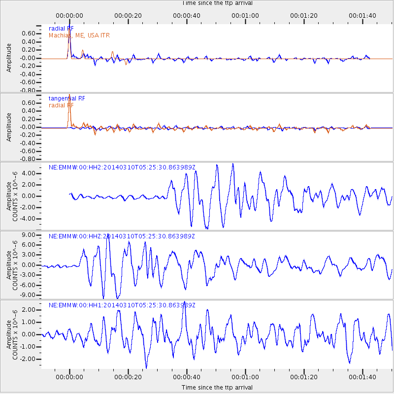
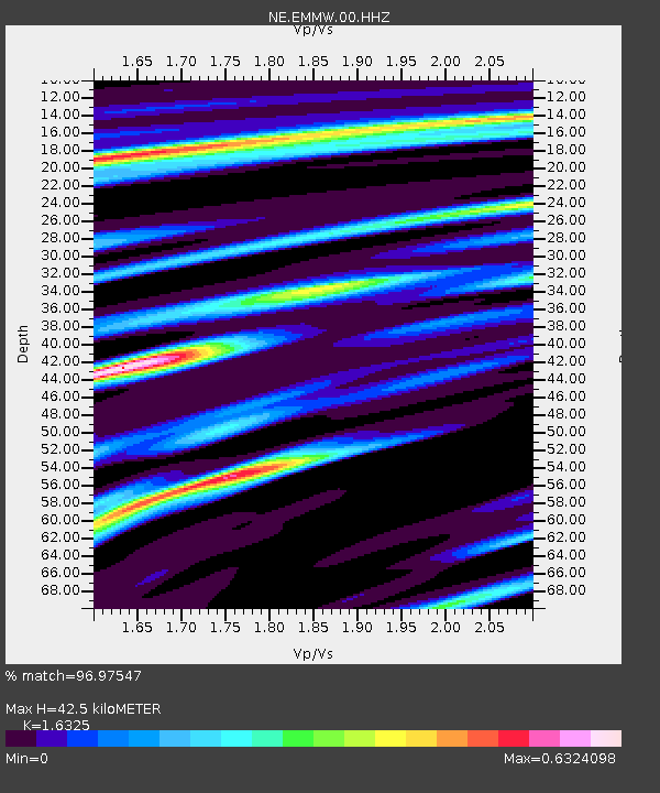
Earthquake location: Off Coast Of Northern California
Earthquake latitude/longitude: 40.8/-125.1
Earthquake time(UTC): 2014/03/10 (069) 05:18:13 GMT
Earthquake Depth: 17 km
Earthquake Magnitude: 6.8 MW, 6.8 MWR, 6.9 MWW, 6.9 MWB, 7.0 MI, 7.0 MWC
Earthquake Catalog/Contributor: NEIC PDE/NEIC COMCAT
Network: NE New England Seismic Network
Station: EMMW Machias, ME, USA
Lat/Lon: 44.71 N/67.46 W
Elevation: 35 m
Distance: 41.8 deg
Az: 64.788 deg
Baz: 285.674 deg
Ray Param: 0.073569976
Estimated Moho Depth: 42.5 km
Estimated Crust Vp/Vs: 1.63
Assumed Crust Vp: 6.419 km/s
Estimated Crust Vs: 3.932 km/s
Estimated Crust Poisson's Ratio: 0.20
Radial Match: 96.97547 %
Radial Bump: 264
Transverse Match: 87.190674 %
Transverse Bump: 400
SOD ConfigId: 626651
Insert Time: 2014-04-21 03:06:34.611 +0000
GWidth: 2.5
Max Bumps: 400
Tol: 0.001

Signal To Noise

ChannelStoNSTALTA
NE:EMMW:00:HHZ:20140310T05:25:30.863989Z5.2034871.5798151E-63.03607E-7
NE:EMMW:00:HH1:20140310T05:25:30.863989Z1.49711563.9146013E-72.6147623E-7
NE:EMMW:00:HH2:20140310T05:25:30.863989Z3.98852471.0038754E-62.516909E-7
Arrivals
Ps4.5 SECOND
PpPs16 SECOND
PsPs/PpSs21 SECOND