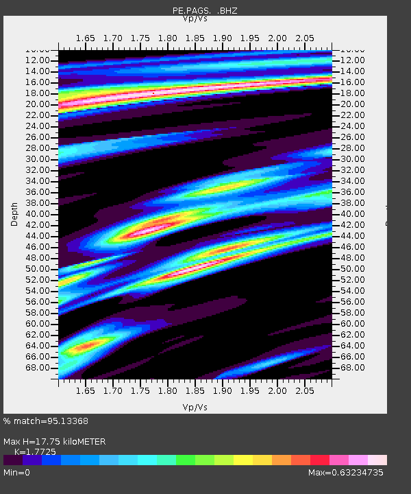
PAGS PA Geological Survey - Earthquake Result Viewer

Earthquake location: Off Coast Of Northern California
Earthquake latitude/longitude: 40.8/-125.1
Earthquake time(UTC): 2014/03/10 (069) 05:18:13 GMT
Earthquake Depth: 17 km
Earthquake Magnitude: 6.8 MW, 6.8 MWR, 6.9 MWW, 6.9 MWB, 7.0 MI, 7.0 MWC
Earthquake Catalog/Contributor: NEIC PDE/NEIC COMCAT
Network: PE Penn State Network
Station: PAGS PA Geological Survey
Lat/Lon: 40.23 N/76.72 W
Elevation: 120 m
Distance: 36.4 deg
Az: 74.651 deg
Baz: 287.1 deg
Ray Param: 0.07667005
Estimated Moho Depth: 17.75 km
Estimated Crust Vp/Vs: 1.77
Assumed Crust Vp: 6.121 km/s
Estimated Crust Vs: 3.453 km/s
Estimated Crust Poisson's Ratio: 0.27
Radial Match: 95.13368 %
Radial Bump: 172
Transverse Match: 80.027 %
Transverse Bump: 400
SOD ConfigId: 626651
Insert Time: 2014-04-21 03:07:24.773 +0000
GWidth: 2.5
Max Bumps: 400
Tol: 0.001

Signal To Noise

ChannelStoNSTALTA
PE:PAGS: :BHZ:20140310T05:24:46.340002Z18.1018923.2525827E-61.796819E-7
PE:PAGS: :BHN:20140310T05:24:46.340002Z2.96627455.2494806E-71.769722E-7
PE:PAGS: :BHE:20140310T05:24:46.340002Z10.2926681.739504E-61.6900418E-7
Arrivals
Ps2.4 SECOND
PpPs7.5 SECOND
PsPs/PpSs9.9 SECOND