You are here: Home > Network List > GS - US Geological Survey Networks Stations List
> Station KAN10 Keim Farm > Earthquake Result Viewer
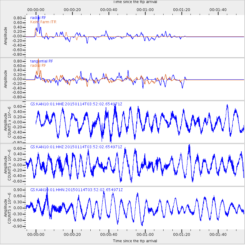
KAN10 Keim Farm - Earthquake Result Viewer
*The percent match for this event was below the threshold and hence no stack was calculated.
| Earthquake location: |
Tonga Islands |
| Earthquake latitude/longitude: |
-15.3/-173.1 |
| Earthquake time(UTC): |
2015/01/14 (014) 03:39:48 GMT |
| Earthquake Depth: |
29 km |
| Earthquake Magnitude: |
5.0 MW, 4.7 mb, 4.1 MS |
| Earthquake Catalog/Contributor: |
ISC/ISC |
|
| Network: |
GS US Geological Survey Networks |
| Station: |
KAN10 Keim Farm |
| Lat/Lon: |
37.12 N/98.10 W |
| Elevation: |
417 m |
|
| Distance: |
87.6 deg |
| Az: |
50.616 deg |
| Baz: |
248.957 deg |
| Ray Param: |
$rayparam |
*The percent match for this event was below the threshold and hence was not used in the summary stack. |
|
| Radial Match: |
71.12165 % |
| Radial Bump: |
400 |
| Transverse Match: |
57.542778 % |
| Transverse Bump: |
400 |
| SOD ConfigId: |
3390531 |
| Insert Time: |
2019-04-16 01:10:34.321 +0000 |
| GWidth: |
2.5 |
| Max Bumps: |
400 |
| Tol: |
0.001 |
|
Signal To Noise
| Channel | StoN | STA | LTA |
| GS:KAN10:01:HHZ:20150114T03:52:02.654971Z | 0.84018224 | 2.3509874E-7 | 2.7981875E-7 |
| GS:KAN10:01:HHN:20150114T03:52:02.654971Z | 1.0104529 | 2.2300631E-7 | 2.2069938E-7 |
| GS:KAN10:01:HHE:20150114T03:52:02.654971Z | 0.9605695 | 2.6686342E-7 | 2.7781792E-7 |
| Arrivals |
| Ps | |
| PpPs | |
| PsPs/PpSs | |


