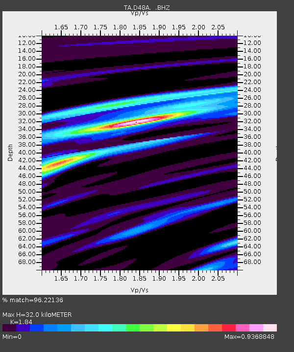
D48A Paudash Township, ON, CAN - Earthquake Result Viewer

Earthquake location: Off Coast Of Northern California
Earthquake latitude/longitude: 40.8/-125.1
Earthquake time(UTC): 2014/03/10 (069) 05:18:13 GMT
Earthquake Depth: 17 km
Earthquake Magnitude: 6.8 MW, 6.8 MWR, 6.9 MWW, 6.9 MWB, 7.0 MI, 7.0 MWC
Earthquake Catalog/Contributor: NEIC PDE/NEIC COMCAT
Network: TA USArray Transportable Network (new EarthScope stations)
Station: D48A Paudash Township, ON, CAN
Lat/Lon: 47.17 N/81.81 W
Elevation: 434 m
Distance: 31.5 deg
Az: 63.676 deg
Baz: 274.471 deg
Ray Param: 0.07904411
Estimated Moho Depth: 32.0 km
Estimated Crust Vp/Vs: 1.84
Assumed Crust Vp: 6.467 km/s
Estimated Crust Vs: 3.514 km/s
Estimated Crust Poisson's Ratio: 0.29
Radial Match: 96.22136 %
Radial Bump: 237
Transverse Match: 84.33449 %
Transverse Bump: 400
SOD ConfigId: 626651
Insert Time: 2014-04-21 03:09:15.424 +0000
GWidth: 2.5
Max Bumps: 400
Tol: 0.001

Signal To Noise

ChannelStoNSTALTA
TA:D48A: :BHZ:20140310T05:24:03.549994Z13.2589032.2220154E-61.6758668E-7
TA:D48A: :BHN:20140310T05:24:03.549994Z0.88481421.5777606E-71.7831546E-7
TA:D48A: :BHE:20140310T05:24:03.549994Z10.8295441.5091022E-61.3935048E-7
Arrivals
Ps4.5 SECOND
PpPs13 SECOND
PsPs/PpSs17 SECOND