You are here: Home > Network List > TA - USArray Transportable Network (new EarthScope stations) Stations List
> Station D53A Lac Vacive, Pontiac, Mrc, QC, CAN > Earthquake Result Viewer
D53A Lac Vacive, Pontiac, Mrc, QC, CAN - Earthquake Result Viewer

| Earthquake location: |
Off Coast Of Northern California |
| Earthquake latitude/longitude: |
40.8/-125.1 |
| Earthquake time(UTC): |
2014/03/10 (069) 05:18:13 GMT |
| Earthquake Depth: |
17 km |
| Earthquake Magnitude: |
6.8 MW, 6.8 MWR, 6.9 MWW, 6.9 MWB, 7.0 MI, 7.0 MWC |
| Earthquake Catalog/Contributor: |
NEIC PDE/NEIC COMCAT |
|
| Network: |
TA USArray Transportable Network (new EarthScope stations) |
| Station: |
D53A Lac Vacive, Pontiac, Mrc, QC, CAN |
| Lat/Lon: |
47.08 N/77.70 W |
| Elevation: |
347 m |
|
| Distance: |
34.3 deg |
| Az: |
63.326 deg |
| Baz: |
277.178 deg |
| Ray Param: |
0.0778042 |
| Estimated Moho Depth: |
51.25 km |
| Estimated Crust Vp/Vs: |
1.60 |
| Assumed Crust Vp: |
6.622 km/s |
| Estimated Crust Vs: |
4.139 km/s |
| Estimated Crust Poisson's Ratio: |
0.18 |
|
| Radial Match: |
96.91179 % |
| Radial Bump: |
236 |
| Transverse Match: |
87.01616 % |
| Transverse Bump: |
400 |
| SOD ConfigId: |
626651 |
| Insert Time: |
2014-04-21 03:09:25.208 +0000 |
| GWidth: |
2.5 |
| Max Bumps: |
400 |
| Tol: |
0.001 |
|
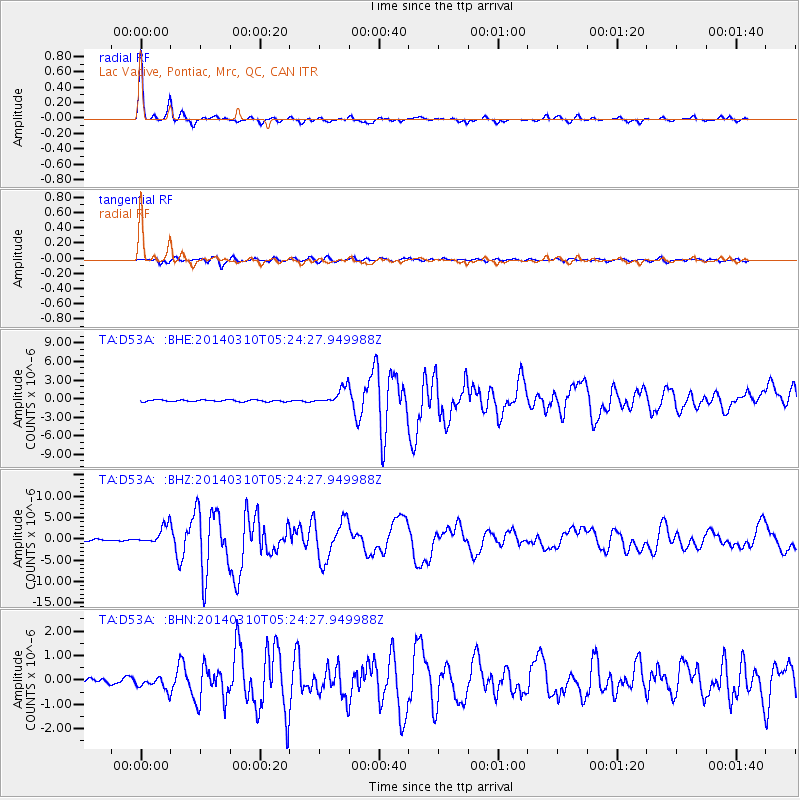
Signal To Noise
| Channel | StoN | STA | LTA |
| TA:D53A: :BHZ:20140310T05:24:27.949988Z | 11.408925 | 2.175503E-6 | 1.9068429E-7 |
| TA:D53A: :BHN:20140310T05:24:27.949988Z | 1.7451054 | 2.684143E-7 | 1.538098E-7 |
| TA:D53A: :BHE:20140310T05:24:27.949988Z | 9.470274 | 1.3583629E-6 | 1.4343438E-7 |
| Arrivals |
| Ps | 5.1 SECOND |
| PpPs | 18 SECOND |
| PsPs/PpSs | 23 SECOND |


