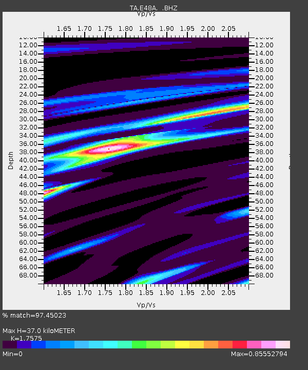
E48A Lockeyer, ON, CAN - Earthquake Result Viewer
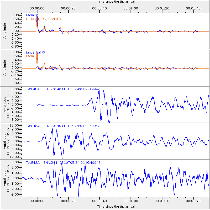
Earthquake location: Off Coast Of Northern California
Earthquake latitude/longitude: 40.8/-125.1
Earthquake time(UTC): 2014/03/10 (069) 05:18:13 GMT
Earthquake Depth: 17 km
Earthquake Magnitude: 6.8 MW, 6.8 MWR, 6.9 MWW, 6.9 MWB, 7.0 MI, 7.0 MWC
Earthquake Catalog/Contributor: NEIC PDE/NEIC COMCAT
Network: TA USArray Transportable Network (new EarthScope stations)
Station: E48A Lockeyer, ON, CAN
Lat/Lon: 46.48 N/82.17 W
Elevation: 347 m
Distance: 31.3 deg
Az: 65.044 deg
Baz: 275.378 deg
Ray Param: 0.07909775
Estimated Moho Depth: 37.0 km
Estimated Crust Vp/Vs: 1.76
Assumed Crust Vp: 6.467 km/s
Estimated Crust Vs: 3.679 km/s
Estimated Crust Poisson's Ratio: 0.26
Radial Match: 97.45023 %
Radial Bump: 242
Transverse Match: 87.53068 %
Transverse Bump: 400
SOD ConfigId: 626651
Insert Time: 2014-04-21 03:09:51.630 +0000
GWidth: 2.5
Max Bumps: 400
Tol: 0.001

Signal To Noise

ChannelStoNSTALTA
TA:E48A: :BHZ:20140310T05:24:01.924994Z13.5710872.1289952E-61.5687729E-7
TA:E48A: :BHN:20140310T05:24:01.924994Z2.25319962.7986798E-71.2420914E-7
TA:E48A: :BHE:20140310T05:24:01.924994Z9.4710161.4194864E-61.4987687E-7
Arrivals
Ps4.7 SECOND
PpPs15 SECOND
PsPs/PpSs19 SECOND