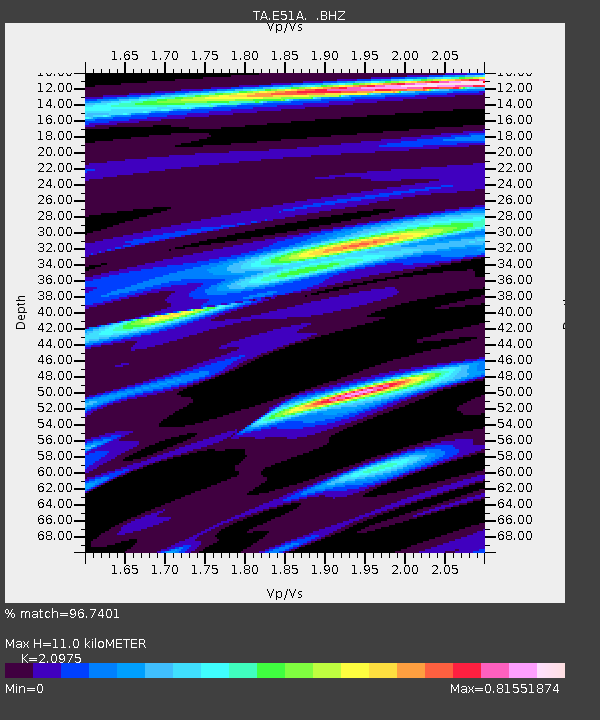
E51A G1948 Merrick Township, ON, CAN - Earthquake Result Viewer

Earthquake location: Off Coast Of Northern California
Earthquake latitude/longitude: 40.8/-125.1
Earthquake time(UTC): 2014/03/10 (069) 05:18:13 GMT
Earthquake Depth: 17 km
Earthquake Magnitude: 6.8 MW, 6.8 MWR, 6.9 MWW, 6.9 MWB, 7.0 MI, 7.0 MWC
Earthquake Catalog/Contributor: NEIC PDE/NEIC COMCAT
Network: TA USArray Transportable Network (new EarthScope stations)
Station: E51A G1948 Merrick Township, ON, CAN
Lat/Lon: 46.53 N/79.49 W
Elevation: 369 m
Distance: 33.1 deg
Az: 64.575 deg
Baz: 276.915 deg
Ray Param: 0.07833588
Estimated Moho Depth: 11.0 km
Estimated Crust Vp/Vs: 2.10
Assumed Crust Vp: 6.622 km/s
Estimated Crust Vs: 3.157 km/s
Estimated Crust Poisson's Ratio: 0.35
Radial Match: 96.7401 %
Radial Bump: 250
Transverse Match: 81.56111 %
Transverse Bump: 400
SOD ConfigId: 626651
Insert Time: 2014-04-21 03:09:55.906 +0000
GWidth: 2.5
Max Bumps: 400
Tol: 0.001

Signal To Noise

ChannelStoNSTALTA
TA:E51A: :BHZ:20140310T05:24:17.924994Z10.8879052.1798653E-62.002098E-7
TA:E51A: :BHN:20140310T05:24:17.924994Z2.84465053.8161218E-71.3415082E-7
TA:E51A: :BHE:20140310T05:24:17.924994Z8.4537061.2879958E-61.5235872E-7
Arrivals
Ps2.0 SECOND
PpPs4.8 SECOND
PsPs/PpSs6.8 SECOND