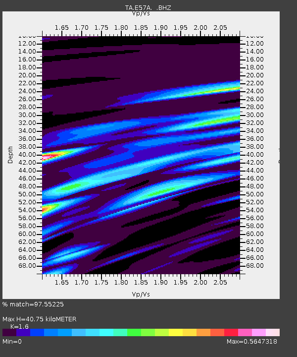
E57A Chemin Saint Guillaume, Saint Donat, QC, CAN - Earthquake Result Viewer
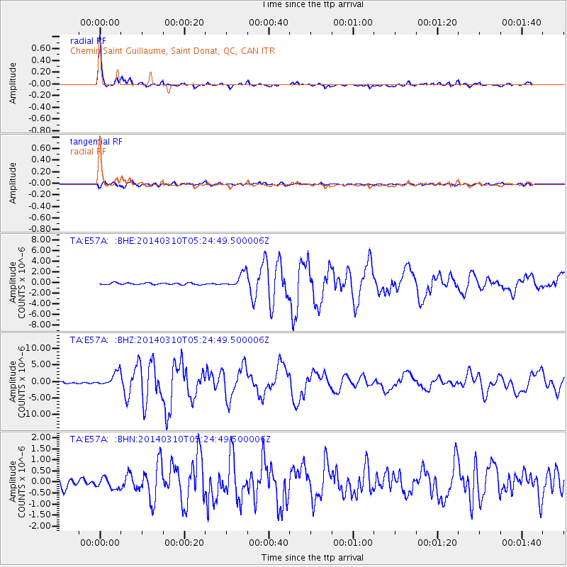
Earthquake location: Off Coast Of Northern California
Earthquake latitude/longitude: 40.8/-125.1
Earthquake time(UTC): 2014/03/10 (069) 05:18:13 GMT
Earthquake Depth: 17 km
Earthquake Magnitude: 6.8 MW, 6.8 MWR, 6.9 MWW, 6.9 MWB, 7.0 MI, 7.0 MWC
Earthquake Catalog/Contributor: NEIC PDE/NEIC COMCAT
Network: TA USArray Transportable Network (new EarthScope stations)
Station: E57A Chemin Saint Guillaume, Saint Donat, QC, CAN
Lat/Lon: 46.41 N/74.15 W
Elevation: 572 m
Distance: 36.8 deg
Az: 63.828 deg
Baz: 280.167 deg
Ray Param: 0.0764675
Estimated Moho Depth: 40.75 km
Estimated Crust Vp/Vs: 1.60
Assumed Crust Vp: 6.61 km/s
Estimated Crust Vs: 4.131 km/s
Estimated Crust Poisson's Ratio: 0.18
Radial Match: 97.55225 %
Radial Bump: 278
Transverse Match: 83.752914 %
Transverse Bump: 400
SOD ConfigId: 626651
Insert Time: 2014-04-21 03:10:08.863 +0000
GWidth: 2.5
Max Bumps: 400
Tol: 0.001

Signal To Noise

ChannelStoNSTALTA
TA:E57A: :BHZ:20140310T05:24:49.500006Z10.1830662.1756116E-62.1364994E-7
TA:E57A: :BHN:20140310T05:24:49.500006Z1.07189992.4292538E-72.2663066E-7
TA:E57A: :BHE:20140310T05:24:49.500006Z8.5329231.4079961E-61.6500749E-7
Arrivals
Ps4.0 SECOND
PpPs15 SECOND
PsPs/PpSs19 SECOND