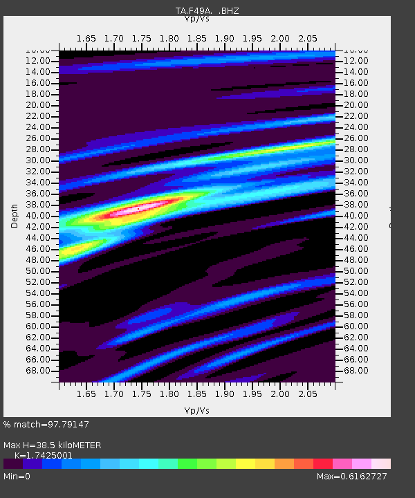
F49A Sandfield, ON, CAN - Earthquake Result Viewer
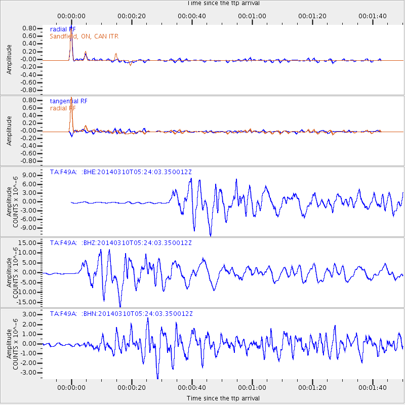
Earthquake location: Off Coast Of Northern California
Earthquake latitude/longitude: 40.8/-125.1
Earthquake time(UTC): 2014/03/10 (069) 05:18:13 GMT
Earthquake Depth: 17 km
Earthquake Magnitude: 6.8 MW, 6.8 MWR, 6.9 MWW, 6.9 MWB, 7.0 MI, 7.0 MWC
Earthquake Catalog/Contributor: NEIC PDE/NEIC COMCAT
Network: TA USArray Transportable Network (new EarthScope stations)
Station: F49A Sandfield, ON, CAN
Lat/Lon: 45.76 N/82.04 W
Elevation: 230 m
Distance: 31.5 deg
Az: 66.399 deg
Baz: 276.623 deg
Ray Param: 0.07905485
Estimated Moho Depth: 38.5 km
Estimated Crust Vp/Vs: 1.74
Assumed Crust Vp: 6.483 km/s
Estimated Crust Vs: 3.72 km/s
Estimated Crust Poisson's Ratio: 0.25
Radial Match: 97.79147 %
Radial Bump: 219
Transverse Match: 87.88396 %
Transverse Bump: 400
SOD ConfigId: 626651
Insert Time: 2014-04-21 03:10:28.029 +0000
GWidth: 2.5
Max Bumps: 400
Tol: 0.001

Signal To Noise

ChannelStoNSTALTA
TA:F49A: :BHZ:20140310T05:24:03.350012Z13.2681782.6658786E-62.0092273E-7
TA:F49A: :BHN:20140310T05:24:03.350012Z0.70284681.0367709E-71.475102E-7
TA:F49A: :BHE:20140310T05:24:03.350012Z10.6408151.8275272E-61.7174692E-7
Arrivals
Ps4.8 SECOND
PpPs15 SECOND
PsPs/PpSs20 SECOND