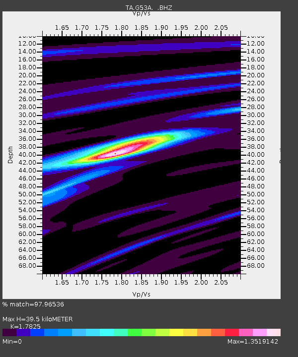
G53A Haliburton, ON, CAN - Earthquake Result Viewer

Earthquake location: Off Coast Of Northern California
Earthquake latitude/longitude: 40.8/-125.1
Earthquake time(UTC): 2014/03/10 (069) 05:18:13 GMT
Earthquake Depth: 17 km
Earthquake Magnitude: 6.8 MW, 6.8 MWR, 6.9 MWW, 6.9 MWB, 7.0 MI, 7.0 MWC
Earthquake Catalog/Contributor: NEIC PDE/NEIC COMCAT
Network: TA USArray Transportable Network (new EarthScope stations)
Station: G53A Haliburton, ON, CAN
Lat/Lon: 45.12 N/78.62 W
Elevation: 333 m
Distance: 33.9 deg
Az: 66.947 deg
Baz: 279.513 deg
Ray Param: 0.07796618
Estimated Moho Depth: 39.5 km
Estimated Crust Vp/Vs: 1.78
Assumed Crust Vp: 6.577 km/s
Estimated Crust Vs: 3.69 km/s
Estimated Crust Poisson's Ratio: 0.27
Radial Match: 97.96536 %
Radial Bump: 231
Transverse Match: 85.902954 %
Transverse Bump: 400
SOD ConfigId: 626651
Insert Time: 2014-04-21 03:10:55.647 +0000
GWidth: 2.5
Max Bumps: 400
Tol: 0.001

Signal To Noise

ChannelStoNSTALTA
TA:G53A: :BHZ:20140310T05:24:24.900Z12.7248352.8363488E-62.2289868E-7
TA:G53A: :BHN:20140310T05:24:24.900Z2.175093.0656454E-71.4094338E-7
TA:G53A: :BHE:20140310T05:24:24.900Z10.8160761.8109387E-61.6743029E-7
Arrivals
Ps5.1 SECOND
PpPs15 SECOND
PsPs/PpSs21 SECOND