G57A Newington, ON, CAN - Earthquake Result Viewer
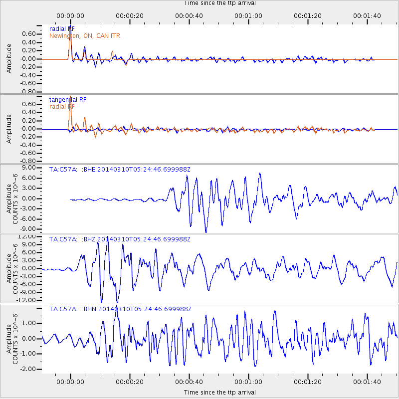
Earthquake location: Off Coast Of Northern California
Earthquake latitude/longitude: 40.8/-125.1
Earthquake time(UTC): 2014/03/10 (069) 05:18:13 GMT
Earthquake Depth: 17 km
Earthquake Magnitude: 6.8 MW, 6.8 MWR, 6.9 MWW, 6.9 MWB, 7.0 MI, 7.0 MWC
Earthquake Catalog/Contributor: NEIC PDE/NEIC COMCAT
Network: TA USArray Transportable Network (new EarthScope stations)
Station: G57A Newington, ON, CAN
Lat/Lon: 45.10 N/74.99 W
Elevation: 96 m
Distance: 36.5 deg
Az: 66.166 deg
Baz: 281.444 deg
Ray Param: 0.07664796
Estimated Moho Depth: 18.25 km
Estimated Crust Vp/Vs: 1.60
Assumed Crust Vp: 6.419 km/s
Estimated Crust Vs: 4.012 km/s
Estimated Crust Poisson's Ratio: 0.18
Radial Match: 96.56924 %
Radial Bump: 354
Transverse Match: 78.70006 %
Transverse Bump: 400
SOD ConfigId: 626651
Insert Time: 2014-04-21 03:11:03.078 +0000
GWidth: 2.5
Max Bumps: 400
Tol: 0.001

Signal To Noise

ChannelStoNSTALTA
TA:G57A: :BHZ:20140310T05:24:46.699988Z12.7591042.6677142E-62.0908321E-7
TA:G57A: :BHN:20140310T05:24:46.699988Z1.47260363.009708E-72.0438006E-7
TA:G57A: :BHE:20140310T05:24:46.699988Z9.4988481.6667832E-61.7547214E-7
Arrivals
Ps1.9 SECOND
PpPs6.8 SECOND
PsPs/PpSs8.7 SECOND