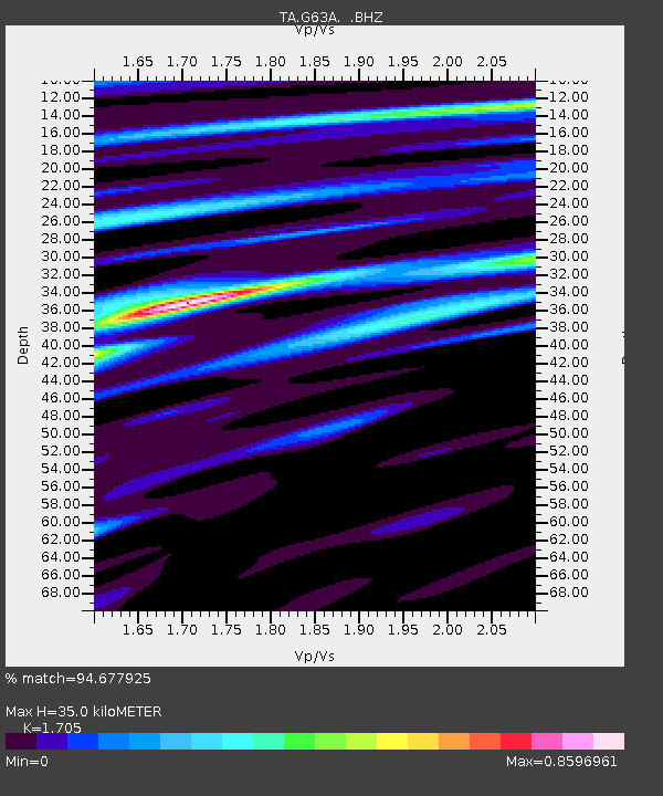
G63A Kingsbury, ME, USA - Earthquake Result Viewer

Earthquake location: Off Coast Of Northern California
Earthquake latitude/longitude: 40.8/-125.1
Earthquake time(UTC): 2014/03/10 (069) 05:18:13 GMT
Earthquake Depth: 17 km
Earthquake Magnitude: 6.8 MW, 6.8 MWR, 6.9 MWW, 6.9 MWB, 7.0 MI, 7.0 MWC
Earthquake Catalog/Contributor: NEIC PDE/NEIC COMCAT
Network: TA USArray Transportable Network (new EarthScope stations)
Station: G63A Kingsbury, ME, USA
Lat/Lon: 45.11 N/69.62 W
Elevation: 363 m
Distance: 40.2 deg
Az: 64.791 deg
Baz: 284.156 deg
Ray Param: 0.07453006
Estimated Moho Depth: 35.0 km
Estimated Crust Vp/Vs: 1.71
Assumed Crust Vp: 6.419 km/s
Estimated Crust Vs: 3.765 km/s
Estimated Crust Poisson's Ratio: 0.24
Radial Match: 94.677925 %
Radial Bump: 329
Transverse Match: 82.19837 %
Transverse Bump: 400
SOD ConfigId: 626651
Insert Time: 2014-04-21 03:11:17.490 +0000
GWidth: 2.5
Max Bumps: 400
Tol: 0.001

Signal To Noise

ChannelStoNSTALTA
TA:G63A: :BHZ:20140310T05:25:17.798987Z8.4900261.9340723E-62.2780522E-7
TA:G63A: :BHN:20140310T05:25:17.798987Z1.04658512.870669E-72.7428914E-7
TA:G63A: :BHE:20140310T05:25:17.798987Z6.5486981.0517614E-61.6060619E-7
Arrivals
Ps4.1 SECOND
PpPs14 SECOND
PsPs/PpSs18 SECOND