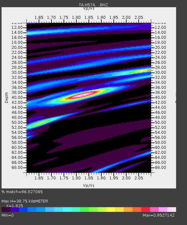
H57A Richville, NY, USA - Earthquake Result Viewer
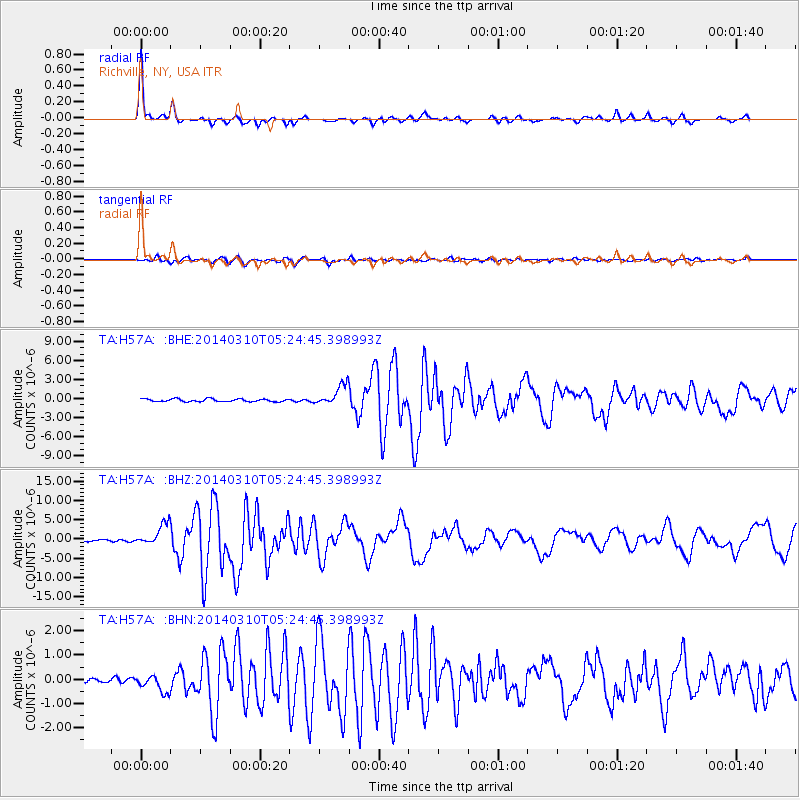
Earthquake location: Off Coast Of Northern California
Earthquake latitude/longitude: 40.8/-125.1
Earthquake time(UTC): 2014/03/10 (069) 05:18:13 GMT
Earthquake Depth: 17 km
Earthquake Magnitude: 6.8 MW, 6.8 MWR, 6.9 MWW, 6.9 MWB, 7.0 MI, 7.0 MWC
Earthquake Catalog/Contributor: NEIC PDE/NEIC COMCAT
Network: TA USArray Transportable Network (new EarthScope stations)
Station: H57A Richville, NY, USA
Lat/Lon: 44.46 N/75.39 W
Elevation: 132 m
Distance: 36.3 deg
Az: 67.323 deg
Baz: 282.091 deg
Ray Param: 0.07673053
Estimated Moho Depth: 38.75 km
Estimated Crust Vp/Vs: 1.83
Assumed Crust Vp: 6.419 km/s
Estimated Crust Vs: 3.517 km/s
Estimated Crust Poisson's Ratio: 0.29
Radial Match: 96.827065 %
Radial Bump: 280
Transverse Match: 88.318726 %
Transverse Bump: 400
SOD ConfigId: 626651
Insert Time: 2014-04-21 03:11:34.904 +0000
GWidth: 2.5
Max Bumps: 400
Tol: 0.001

Signal To Noise

ChannelStoNSTALTA
TA:H57A: :BHZ:20140310T05:24:45.398993Z11.8647682.7562105E-62.323021E-7
TA:H57A: :BHN:20140310T05:24:45.398993Z2.39891363.2644942E-71.3608219E-7
TA:H57A: :BHE:20140310T05:24:45.398993Z7.4120731.597214E-62.1548817E-7
Arrivals
Ps5.4 SECOND
PpPs16 SECOND
PsPs/PpSs21 SECOND