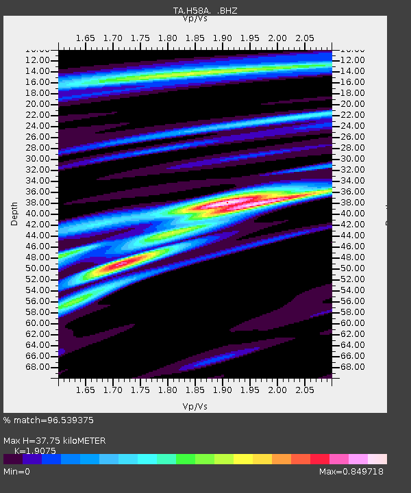
H58A Gabriels, NY, USA - Earthquake Result Viewer

Earthquake location: Off Coast Of Northern California
Earthquake latitude/longitude: 40.8/-125.1
Earthquake time(UTC): 2014/03/10 (069) 05:18:13 GMT
Earthquake Depth: 17 km
Earthquake Magnitude: 6.8 MW, 6.8 MWR, 6.9 MWW, 6.9 MWB, 7.0 MI, 7.0 MWC
Earthquake Catalog/Contributor: NEIC PDE/NEIC COMCAT
Network: TA USArray Transportable Network (new EarthScope stations)
Station: H58A Gabriels, NY, USA
Lat/Lon: 44.42 N/74.18 W
Elevation: 537 m
Distance: 37.2 deg
Az: 67.085 deg
Baz: 282.745 deg
Ray Param: 0.07626402
Estimated Moho Depth: 37.75 km
Estimated Crust Vp/Vs: 1.91
Assumed Crust Vp: 6.419 km/s
Estimated Crust Vs: 3.365 km/s
Estimated Crust Poisson's Ratio: 0.31
Radial Match: 96.539375 %
Radial Bump: 258
Transverse Match: 89.56612 %
Transverse Bump: 400
SOD ConfigId: 626651
Insert Time: 2014-04-21 03:11:36.070 +0000
GWidth: 2.5
Max Bumps: 400
Tol: 0.001

Signal To Noise

ChannelStoNSTALTA
TA:H58A: :BHZ:20140310T05:24:52.674994Z16.4772742.6718064E-61.62151E-7
TA:H58A: :BHN:20140310T05:24:52.674994Z2.73832734.1735734E-71.5241324E-7
TA:H58A: :BHE:20140310T05:24:52.674994Z8.730021.5932686E-61.8250459E-7
Arrivals
Ps5.7 SECOND
PpPs16 SECOND
PsPs/PpSs22 SECOND