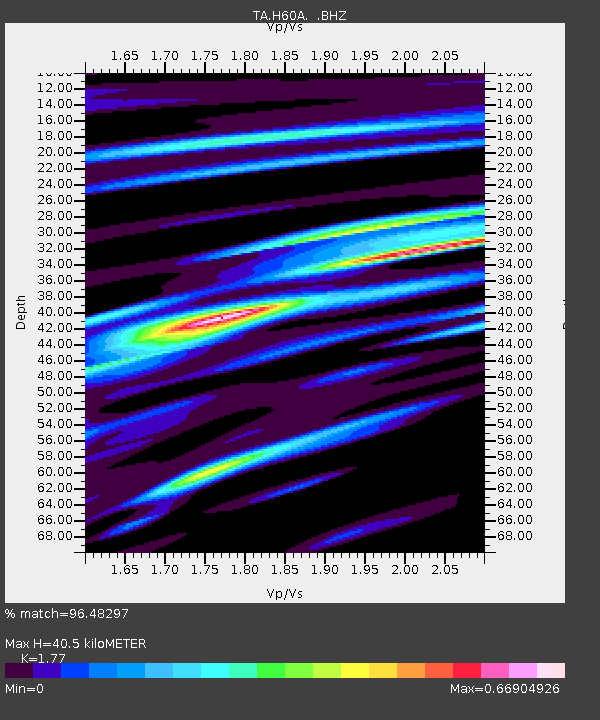
H60A Morristown, VT, USA - Earthquake Result Viewer

Earthquake location: Off Coast Of Northern California
Earthquake latitude/longitude: 40.8/-125.1
Earthquake time(UTC): 2014/03/10 (069) 05:18:13 GMT
Earthquake Depth: 17 km
Earthquake Magnitude: 6.8 MW, 6.8 MWR, 6.9 MWW, 6.9 MWB, 7.0 MI, 7.0 MWC
Earthquake Catalog/Contributor: NEIC PDE/NEIC COMCAT
Network: TA USArray Transportable Network (new EarthScope stations)
Station: H60A Morristown, VT, USA
Lat/Lon: 44.56 N/72.70 W
Elevation: 459 m
Distance: 38.2 deg
Az: 66.466 deg
Baz: 283.29 deg
Ray Param: 0.07569749
Estimated Moho Depth: 40.5 km
Estimated Crust Vp/Vs: 1.77
Assumed Crust Vp: 6.419 km/s
Estimated Crust Vs: 3.627 km/s
Estimated Crust Poisson's Ratio: 0.27
Radial Match: 96.48297 %
Radial Bump: 317
Transverse Match: 77.03813 %
Transverse Bump: 400
SOD ConfigId: 626651
Insert Time: 2014-04-21 03:11:41.021 +0000
GWidth: 2.5
Max Bumps: 400
Tol: 0.001

Signal To Noise

ChannelStoNSTALTA
TA:H60A: :BHZ:20140310T05:25:01.125006Z7.39798742.1142416E-62.8578606E-7
TA:H60A: :BHN:20140310T05:25:01.125006Z2.46281224.7886977E-71.9444023E-7
TA:H60A: :BHE:20140310T05:25:01.125006Z4.5933891.3663989E-62.9747076E-7
Arrivals
Ps5.2 SECOND
PpPs16 SECOND
PsPs/PpSs21 SECOND