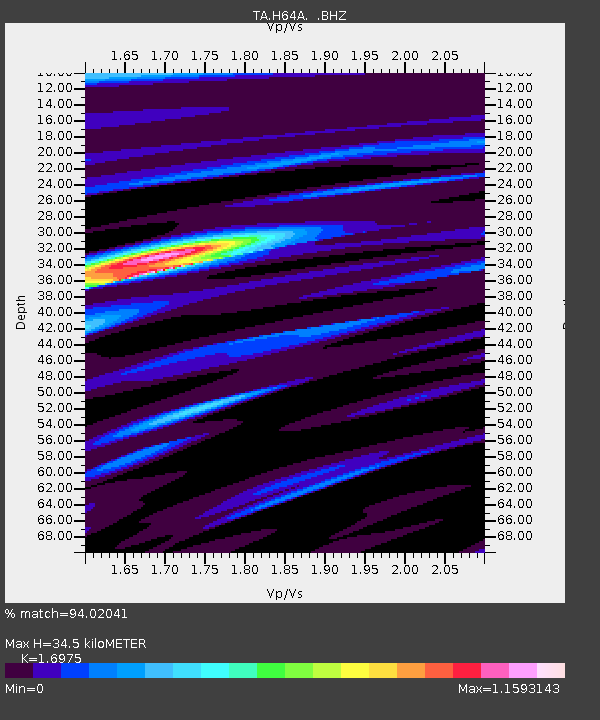
H64A Troy, ME, USA - Earthquake Result Viewer

Earthquake location: Off Coast Of Northern California
Earthquake latitude/longitude: 40.8/-125.1
Earthquake time(UTC): 2014/03/10 (069) 05:18:13 GMT
Earthquake Depth: 17 km
Earthquake Magnitude: 6.8 MW, 6.8 MWR, 6.9 MWW, 6.9 MWB, 7.0 MI, 7.0 MWC
Earthquake Catalog/Contributor: NEIC PDE/NEIC COMCAT
Network: TA USArray Transportable Network (new EarthScope stations)
Station: H64A Troy, ME, USA
Lat/Lon: 44.64 N/69.22 W
Elevation: 158 m
Distance: 40.6 deg
Az: 65.389 deg
Baz: 284.892 deg
Ray Param: 0.07431109
Estimated Moho Depth: 34.5 km
Estimated Crust Vp/Vs: 1.70
Assumed Crust Vp: 6.419 km/s
Estimated Crust Vs: 3.782 km/s
Estimated Crust Poisson's Ratio: 0.23
Radial Match: 94.02041 %
Radial Bump: 358
Transverse Match: 83.15406 %
Transverse Bump: 400
SOD ConfigId: 626651
Insert Time: 2014-04-21 03:11:51.291 +0000
GWidth: 2.5
Max Bumps: 400
Tol: 0.001

Signal To Noise

ChannelStoNSTALTA
TA:H64A: :BHZ:20140310T05:25:21.049994Z4.9654981.5370547E-63.0954695E-7
TA:H64A: :BHN:20140310T05:25:21.049994Z1.01432792.925776E-72.8844477E-7
TA:H64A: :BHE:20140310T05:25:21.049994Z5.38427971.021875E-61.8978862E-7
Arrivals
Ps4.0 SECOND
PpPs13 SECOND
PsPs/PpSs18 SECOND