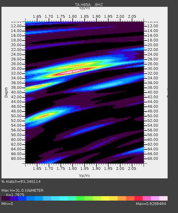
H65A Eastbrook, ME, USA - Earthquake Result Viewer

Earthquake location: Off Coast Of Northern California
Earthquake latitude/longitude: 40.8/-125.1
Earthquake time(UTC): 2014/03/10 (069) 05:18:13 GMT
Earthquake Depth: 17 km
Earthquake Magnitude: 6.8 MW, 6.8 MWR, 6.9 MWW, 6.9 MWB, 7.0 MI, 7.0 MWC
Earthquake Catalog/Contributor: NEIC PDE/NEIC COMCAT
Network: TA USArray Transportable Network (new EarthScope stations)
Station: H65A Eastbrook, ME, USA
Lat/Lon: 44.70 N/68.25 W
Elevation: 98 m
Distance: 41.2 deg
Az: 65.032 deg
Baz: 285.303 deg
Ray Param: 0.07391095
Estimated Moho Depth: 31.0 km
Estimated Crust Vp/Vs: 1.80
Assumed Crust Vp: 6.419 km/s
Estimated Crust Vs: 3.571 km/s
Estimated Crust Poisson's Ratio: 0.28
Radial Match: 93.348114 %
Radial Bump: 316
Transverse Match: 78.27308 %
Transverse Bump: 400
SOD ConfigId: 626651
Insert Time: 2014-04-21 03:11:53.380 +0000
GWidth: 2.5
Max Bumps: 400
Tol: 0.001

Signal To Noise

ChannelStoNSTALTA
TA:H65A: :BHZ:20140310T05:25:26.449011Z4.34612561.8196056E-64.18673E-7
TA:H65A: :BHN:20140310T05:25:26.449011Z1.39495434.4078837E-73.1598768E-7
TA:H65A: :BHE:20140310T05:25:26.449011Z2.62815551.0790096E-64.1055776E-7
Arrivals
Ps4.1 SECOND
PpPs13 SECOND
PsPs/PpSs17 SECOND