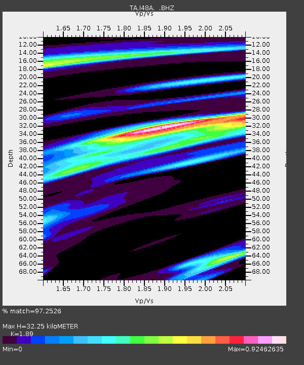
I48A Sherman Twp, MI, USA - Earthquake Result Viewer
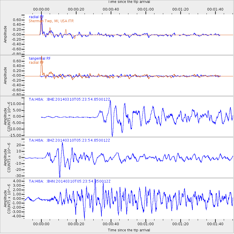
Earthquake location: Off Coast Of Northern California
Earthquake latitude/longitude: 40.8/-125.1
Earthquake time(UTC): 2014/03/10 (069) 05:18:13 GMT
Earthquake Depth: 17 km
Earthquake Magnitude: 6.8 MW, 6.8 MWR, 6.9 MWW, 6.9 MWB, 7.0 MI, 7.0 MWC
Earthquake Catalog/Contributor: NEIC PDE/NEIC COMCAT
Network: TA USArray Transportable Network (new EarthScope stations)
Station: I48A Sherman Twp, MI, USA
Lat/Lon: 44.19 N/83.70 W
Elevation: 192 m
Distance: 30.5 deg
Az: 69.731 deg
Baz: 278.311 deg
Ray Param: 0.07930886
Estimated Moho Depth: 32.25 km
Estimated Crust Vp/Vs: 1.89
Assumed Crust Vp: 6.483 km/s
Estimated Crust Vs: 3.43 km/s
Estimated Crust Poisson's Ratio: 0.31
Radial Match: 97.2526 %
Radial Bump: 316
Transverse Match: 81.846 %
Transverse Bump: 400
SOD ConfigId: 626651
Insert Time: 2014-04-21 03:11:58.684 +0000
GWidth: 2.5
Max Bumps: 400
Tol: 0.001

Signal To Noise

ChannelStoNSTALTA
TA:I48A: :BHZ:20140310T05:23:54.850012Z15.8222483.9059605E-62.4686508E-7
TA:I48A: :BHN:20140310T05:23:54.850012Z0.787942771.8003847E-72.2849181E-7
TA:I48A: :BHE:20140310T05:23:54.850012Z9.6349322.329253E-62.4175085E-7
Arrivals
Ps4.8 SECOND
PpPs13 SECOND
PsPs/PpSs18 SECOND