You are here: Home > Network List > US - United States National Seismic Network Stations List
> Station BRAL Brewton, Alabama, USA > Earthquake Result Viewer
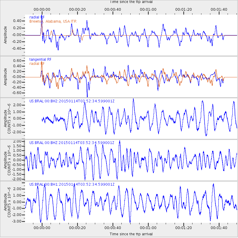
BRAL Brewton, Alabama, USA - Earthquake Result Viewer
*The percent match for this event was below the threshold and hence no stack was calculated.
| Earthquake location: |
Tonga Islands |
| Earthquake latitude/longitude: |
-15.3/-173.1 |
| Earthquake time(UTC): |
2015/01/14 (014) 03:39:48 GMT |
| Earthquake Depth: |
29 km |
| Earthquake Magnitude: |
5.0 MW, 4.7 mb, 4.1 MS |
| Earthquake Catalog/Contributor: |
ISC/ISC |
|
| Network: |
US United States National Seismic Network |
| Station: |
BRAL Brewton, Alabama, USA |
| Lat/Lon: |
31.17 N/87.05 W |
| Elevation: |
61 m |
|
| Distance: |
94.5 deg |
| Az: |
59.075 deg |
| Baz: |
254.993 deg |
| Ray Param: |
$rayparam |
*The percent match for this event was below the threshold and hence was not used in the summary stack. |
|
| Radial Match: |
59.71788 % |
| Radial Bump: |
400 |
| Transverse Match: |
51.155907 % |
| Transverse Bump: |
348 |
| SOD ConfigId: |
3390531 |
| Insert Time: |
2019-04-16 01:13:25.075 +0000 |
| GWidth: |
2.5 |
| Max Bumps: |
400 |
| Tol: |
0.001 |
|
Signal To Noise
| Channel | StoN | STA | LTA |
| US:BRAL:00:BHZ:20150114T03:52:34.599001Z | 1.1220726 | 7.008137E-7 | 6.2457076E-7 |
| US:BRAL:00:BH1:20150114T03:52:34.599001Z | 2.2151384 | 1.8468007E-6 | 8.3371793E-7 |
| US:BRAL:00:BH2:20150114T03:52:34.599001Z | 1.0835869 | 8.298653E-7 | 7.6585025E-7 |
| Arrivals |
| Ps | |
| PpPs | |
| PsPs/PpSs | |


