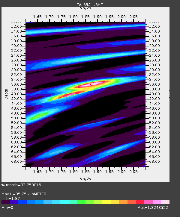
I55A Frankford, ON, CAN - Earthquake Result Viewer
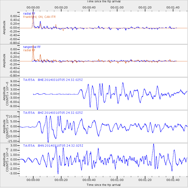
Earthquake location: Off Coast Of Northern California
Earthquake latitude/longitude: 40.8/-125.1
Earthquake time(UTC): 2014/03/10 (069) 05:18:13 GMT
Earthquake Depth: 17 km
Earthquake Magnitude: 6.8 MW, 6.8 MWR, 6.9 MWW, 6.9 MWB, 7.0 MI, 7.0 MWC
Earthquake Catalog/Contributor: NEIC PDE/NEIC COMCAT
Network: TA USArray Transportable Network (new EarthScope stations)
Station: I55A Frankford, ON, CAN
Lat/Lon: 44.22 N/77.68 W
Elevation: 132 m
Distance: 34.8 deg
Az: 68.311 deg
Baz: 281.3 deg
Ray Param: 0.07756134
Estimated Moho Depth: 35.75 km
Estimated Crust Vp/Vs: 1.87
Assumed Crust Vp: 6.577 km/s
Estimated Crust Vs: 3.517 km/s
Estimated Crust Poisson's Ratio: 0.30
Radial Match: 97.750015 %
Radial Bump: 228
Transverse Match: 83.7793 %
Transverse Bump: 400
SOD ConfigId: 626651
Insert Time: 2014-04-21 03:12:08.545 +0000
GWidth: 2.5
Max Bumps: 400
Tol: 0.001

Signal To Noise

ChannelStoNSTALTA
TA:I55A: :BHZ:20140310T05:24:32.025Z11.6094192.797698E-62.409852E-7
TA:I55A: :BHN:20140310T05:24:32.025Z2.91009474.873799E-71.6747906E-7
TA:I55A: :BHE:20140310T05:24:32.025Z9.1777871.6842239E-61.835109E-7
Arrivals
Ps5.1 SECOND
PpPs14 SECOND
PsPs/PpSs20 SECOND