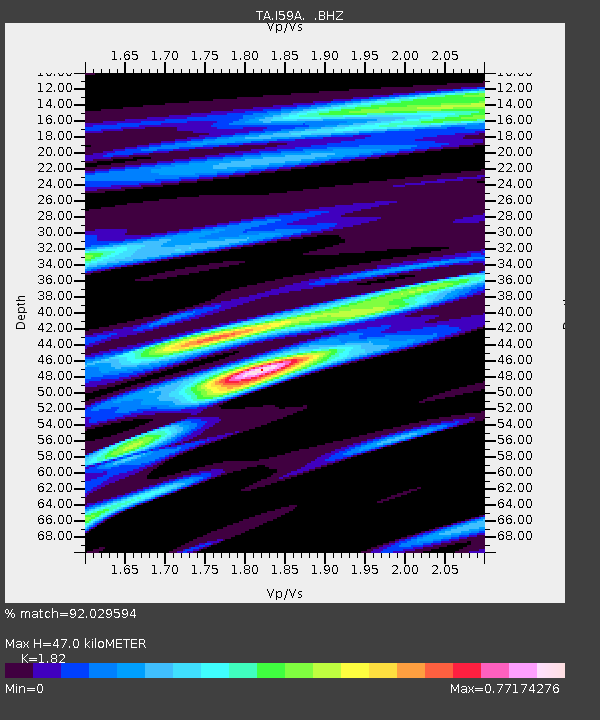
I59A Olmsteadville, NY, USA - Earthquake Result Viewer
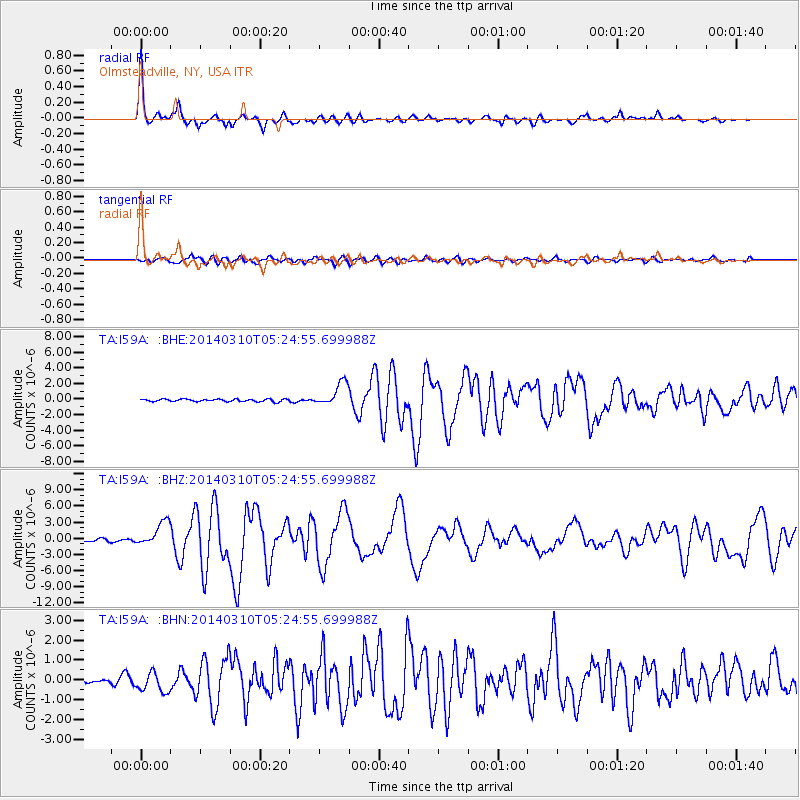
Earthquake location: Off Coast Of Northern California
Earthquake latitude/longitude: 40.8/-125.1
Earthquake time(UTC): 2014/03/10 (069) 05:18:13 GMT
Earthquake Depth: 17 km
Earthquake Magnitude: 6.8 MW, 6.8 MWR, 6.9 MWW, 6.9 MWB, 7.0 MI, 7.0 MWC
Earthquake Catalog/Contributor: NEIC PDE/NEIC COMCAT
Network: TA USArray Transportable Network (new EarthScope stations)
Station: I59A Olmsteadville, NY, USA
Lat/Lon: 43.80 N/73.87 W
Elevation: 390 m
Distance: 37.5 deg
Az: 67.999 deg
Baz: 283.684 deg
Ray Param: 0.07606996
Estimated Moho Depth: 47.0 km
Estimated Crust Vp/Vs: 1.82
Assumed Crust Vp: 6.419 km/s
Estimated Crust Vs: 3.527 km/s
Estimated Crust Poisson's Ratio: 0.28
Radial Match: 92.029594 %
Radial Bump: 358
Transverse Match: 77.124596 %
Transverse Bump: 400
SOD ConfigId: 626651
Insert Time: 2014-04-21 03:12:14.760 +0000
GWidth: 2.5
Max Bumps: 400
Tol: 0.001

Signal To Noise

ChannelStoNSTALTA
TA:I59A: :BHZ:20140310T05:24:55.699988Z10.9304082.2690065E-62.0758664E-7
TA:I59A: :BHN:20140310T05:24:55.699988Z2.95508554.932379E-71.6691155E-7
TA:I59A: :BHE:20140310T05:24:55.699988Z9.8856671.4953793E-61.5126741E-7
Arrivals
Ps6.4 SECOND
PpPs19 SECOND
PsPs/PpSs26 SECOND