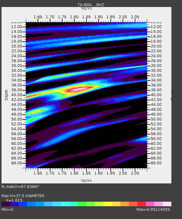
I60A Shoreham, VT, USA - Earthquake Result Viewer

Earthquake location: Off Coast Of Northern California
Earthquake latitude/longitude: 40.8/-125.1
Earthquake time(UTC): 2014/03/10 (069) 05:18:13 GMT
Earthquake Depth: 17 km
Earthquake Magnitude: 6.8 MW, 6.8 MWR, 6.9 MWW, 6.9 MWB, 7.0 MI, 7.0 MWC
Earthquake Catalog/Contributor: NEIC PDE/NEIC COMCAT
Network: TA USArray Transportable Network (new EarthScope stations)
Station: I60A Shoreham, VT, USA
Lat/Lon: 43.84 N/73.29 W
Elevation: 101 m
Distance: 37.9 deg
Az: 67.758 deg
Baz: 283.895 deg
Ray Param: 0.07584001
Estimated Moho Depth: 37.5 km
Estimated Crust Vp/Vs: 1.82
Assumed Crust Vp: 6.419 km/s
Estimated Crust Vs: 3.537 km/s
Estimated Crust Poisson's Ratio: 0.28
Radial Match: 97.63667 %
Radial Bump: 320
Transverse Match: 90.12624 %
Transverse Bump: 400
SOD ConfigId: 626651
Insert Time: 2014-04-21 03:12:17.253 +0000
GWidth: 2.5
Max Bumps: 400
Tol: 0.001

Signal To Noise

ChannelStoNSTALTA
TA:I60A: :BHZ:20140310T05:24:59.049994Z9.256662.5243387E-62.727051E-7
TA:I60A: :BHN:20140310T05:24:59.049994Z2.53130915.693223E-72.2491221E-7
TA:I60A: :BHE:20140310T05:24:59.049994Z8.6989591.7123784E-61.9684865E-7
Arrivals
Ps5.1 SECOND
PpPs15 SECOND
PsPs/PpSs20 SECOND