You are here: Home > Network List > TA - USArray Transportable Network (new EarthScope stations) Stations List
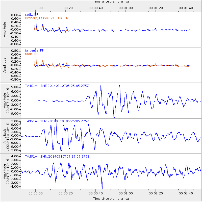
> Station I61A Oroboro, Fairlee, VT, USA > Earthquake Result Viewer
I61A Oroboro, Fairlee, VT, USA - Earthquake Result Viewer
| Earthquake location: |
Off Coast Of Northern California |
| Earthquake latitude/longitude: |
40.8/-125.1 |
| Earthquake time(UTC): |
2014/03/10 (069) 05:18:13 GMT |
| Earthquake Depth: |
17 km |
| Earthquake Magnitude: |
6.8 MW, 6.8 MWR, 6.9 MWW, 6.9 MWB, 7.0 MI, 7.0 MWC |
| Earthquake Catalog/Contributor: |
NEIC PDE/NEIC COMCAT |
|
| Network: |
TA USArray Transportable Network (new EarthScope stations) |
| Station: |
I61A Oroboro, Fairlee, VT, USA |
| Lat/Lon: |
43.93 N/72.21 W |
| Elevation: |
287 m |
|
| Distance: |
38.7 deg |
| Az: |
67.313 deg |
| Baz: |
284.294 deg |
| Ray Param: |
0.075413555 |
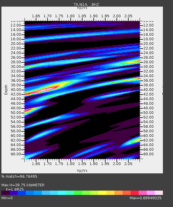
| Estimated Moho Depth: |
39.75 km |
| Estimated Crust Vp/Vs: |
1.69 |
| Assumed Crust Vp: |
6.419 km/s |
| Estimated Crust Vs: |
3.793 km/s |
| Estimated Crust Poisson's Ratio: |
0.23 |
|
| Radial Match: |
96.76495 % |
| Radial Bump: |
262 |
| Transverse Match: |
85.737526 % |
| Transverse Bump: |
400 |
| SOD ConfigId: |
626651 |
| Insert Time: |
2014-04-21 03:12:19.047 +0000 |
| GWidth: |
2.5 |
| Max Bumps: |
400 |
| Tol: |
0.001 |
|
Signal To Noise
| Channel | StoN | STA | LTA |
| TA:I61A: :BHZ:20140310T05:25:05.275Z | 5.178193 | 1.7796921E-6 | 3.4368978E-7 |
| TA:I61A: :BHN:20140310T05:25:05.275Z | 1.3990211 | 3.4643614E-7 | 2.4762753E-7 |
| TA:I61A: :BHE:20140310T05:25:05.275Z | 5.89604 | 1.1887292E-6 | 2.0161485E-7 |
| Arrivals |
| Ps | 4.6 SECOND |
| PpPs | 15 SECOND |
| PsPs/PpSs | 20 SECOND |


