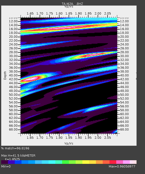
I62A Tamworth, NH, USA - Earthquake Result Viewer

Earthquake location: Off Coast Of Northern California
Earthquake latitude/longitude: 40.8/-125.1
Earthquake time(UTC): 2014/03/10 (069) 05:18:13 GMT
Earthquake Depth: 17 km
Earthquake Magnitude: 6.8 MW, 6.8 MWR, 6.9 MWW, 6.9 MWB, 7.0 MI, 7.0 MWC
Earthquake Catalog/Contributor: NEIC PDE/NEIC COMCAT
Network: TA USArray Transportable Network (new EarthScope stations)
Station: I62A Tamworth, NH, USA
Lat/Lon: 43.87 N/71.34 W
Elevation: 264 m
Distance: 39.3 deg
Az: 67.15 deg
Baz: 284.771 deg
Ray Param: 0.0750525
Estimated Moho Depth: 41.5 km
Estimated Crust Vp/Vs: 1.65
Assumed Crust Vp: 6.419 km/s
Estimated Crust Vs: 3.885 km/s
Estimated Crust Poisson's Ratio: 0.21
Radial Match: 96.8196 %
Radial Bump: 355
Transverse Match: 90.924904 %
Transverse Bump: 400
SOD ConfigId: 626651
Insert Time: 2014-04-21 03:12:21.524 +0000
GWidth: 2.5
Max Bumps: 400
Tol: 0.001

Signal To Noise

ChannelStoNSTALTA
TA:I62A: :BHZ:20140310T05:25:10.500006Z8.1887792.1575465E-62.6347598E-7
TA:I62A: :BHN:20140310T05:25:10.500006Z2.3260234.5097377E-71.9388189E-7
TA:I62A: :BHE:20140310T05:25:10.500006Z7.3543921.1361602E-61.5448731E-7
Arrivals
Ps4.6 SECOND
PpPs16 SECOND
PsPs/PpSs20 SECOND