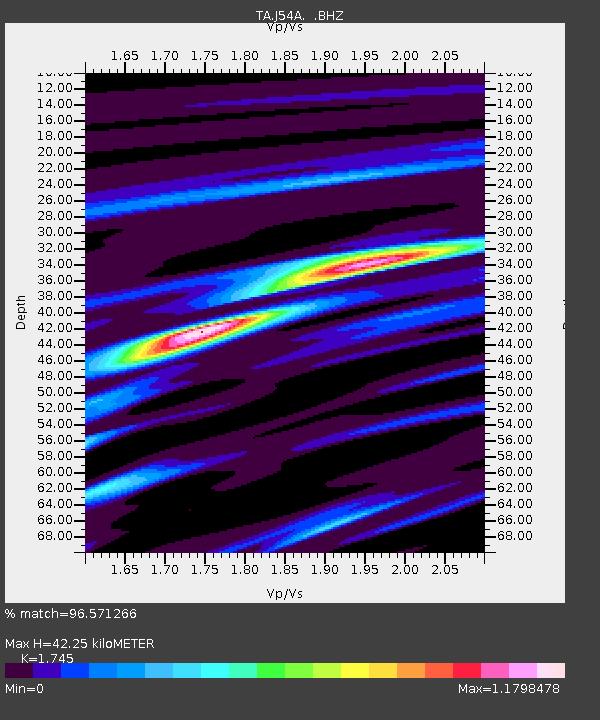
J54A Appleton, NY, USA - Earthquake Result Viewer

Earthquake location: Off Coast Of Northern California
Earthquake latitude/longitude: 40.8/-125.1
Earthquake time(UTC): 2014/03/10 (069) 05:18:13 GMT
Earthquake Depth: 17 km
Earthquake Magnitude: 6.8 MW, 6.8 MWR, 6.9 MWW, 6.9 MWB, 7.0 MI, 7.0 MWC
Earthquake Catalog/Contributor: NEIC PDE/NEIC COMCAT
Network: TA USArray Transportable Network (new EarthScope stations)
Station: J54A Appleton, NY, USA
Lat/Lon: 43.27 N/78.64 W
Elevation: 112 m
Distance: 34.3 deg
Az: 70.19 deg
Baz: 282.188 deg
Ray Param: 0.07781093
Estimated Moho Depth: 42.25 km
Estimated Crust Vp/Vs: 1.75
Assumed Crust Vp: 6.419 km/s
Estimated Crust Vs: 3.679 km/s
Estimated Crust Poisson's Ratio: 0.26
Radial Match: 96.571266 %
Radial Bump: 218
Transverse Match: 87.07651 %
Transverse Bump: 400
SOD ConfigId: 626651
Insert Time: 2014-04-21 03:12:35.241 +0000
GWidth: 2.5
Max Bumps: 400
Tol: 0.001

Signal To Noise

ChannelStoNSTALTA
TA:J54A: :BHZ:20140310T05:24:27.824988Z17.8908773.3557121E-61.8756555E-7
TA:J54A: :BHN:20140310T05:24:27.824988Z2.73547174.3086598E-71.5751067E-7
TA:J54A: :BHE:20140310T05:24:27.824988Z14.9140522.0769726E-61.392628E-7
Arrivals
Ps5.3 SECOND
PpPs17 SECOND
PsPs/PpSs22 SECOND