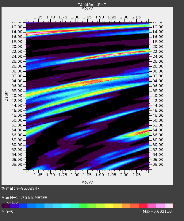
K48A Perry, MI, USA - Earthquake Result Viewer
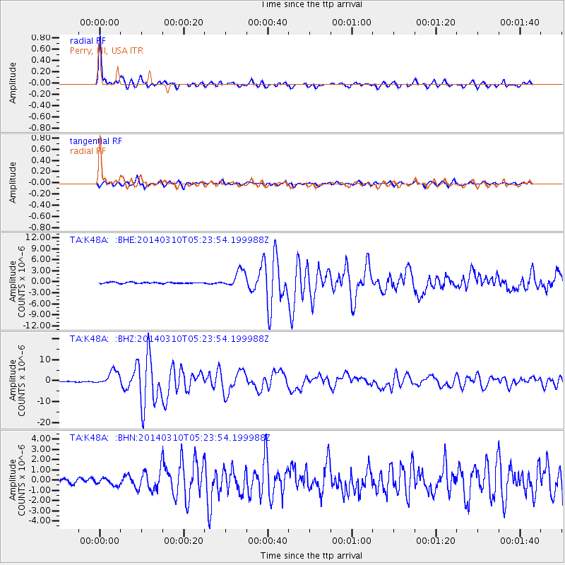
Earthquake location: Off Coast Of Northern California
Earthquake latitude/longitude: 40.8/-125.1
Earthquake time(UTC): 2014/03/10 (069) 05:18:13 GMT
Earthquake Depth: 17 km
Earthquake Magnitude: 6.8 MW, 6.8 MWR, 6.9 MWW, 6.9 MWB, 7.0 MI, 7.0 MWC
Earthquake Catalog/Contributor: NEIC PDE/NEIC COMCAT
Network: TA USArray Transportable Network (new EarthScope stations)
Station: K48A Perry, MI, USA
Lat/Lon: 42.80 N/84.12 W
Elevation: 273 m
Distance: 30.4 deg
Az: 72.522 deg
Baz: 280.431 deg
Ray Param: 0.07932843
Estimated Moho Depth: 14.75 km
Estimated Crust Vp/Vs: 1.60
Assumed Crust Vp: 6.483 km/s
Estimated Crust Vs: 4.052 km/s
Estimated Crust Poisson's Ratio: 0.18
Radial Match: 95.68347 %
Radial Bump: 318
Transverse Match: 88.79549 %
Transverse Bump: 400
SOD ConfigId: 626651
Insert Time: 2014-04-21 03:13:00.122 +0000
GWidth: 2.5
Max Bumps: 400
Tol: 0.001

Signal To Noise

ChannelStoNSTALTA
TA:K48A: :BHZ:20140310T05:23:54.199988Z18.0135773.571444E-61.9826402E-7
TA:K48A: :BHN:20140310T05:23:54.199988Z1.64888123.5965712E-72.1812191E-7
TA:K48A: :BHE:20140310T05:23:54.199988Z14.317072.3606342E-61.648825E-7
Arrivals
Ps1.5 SECOND
PpPs5.4 SECOND
PsPs/PpSs6.9 SECOND