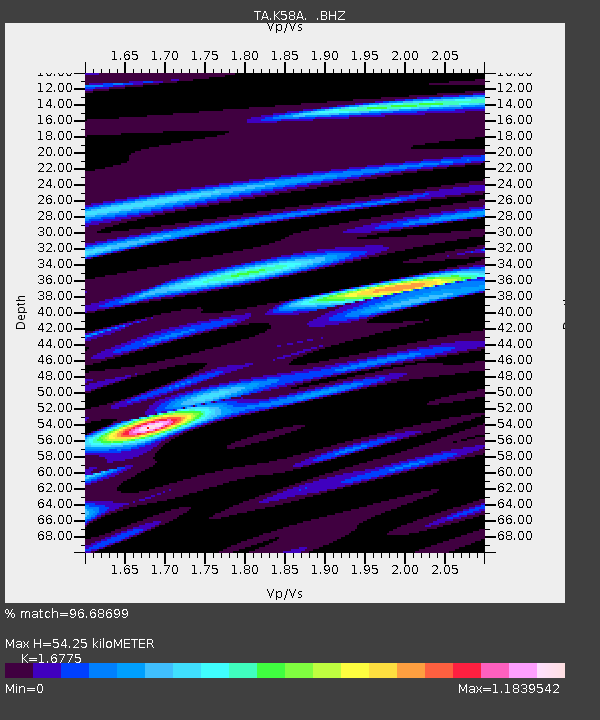
K58A Earlville, NY, USA - Earthquake Result Viewer

Earthquake location: Off Coast Of Northern California
Earthquake latitude/longitude: 40.8/-125.1
Earthquake time(UTC): 2014/03/10 (069) 05:18:13 GMT
Earthquake Depth: 17 km
Earthquake Magnitude: 6.8 MW, 6.8 MWR, 6.9 MWW, 6.9 MWB, 7.0 MI, 7.0 MWC
Earthquake Catalog/Contributor: NEIC PDE/NEIC COMCAT
Network: TA USArray Transportable Network (new EarthScope stations)
Station: K58A Earlville, NY, USA
Lat/Lon: 42.76 N/75.65 W
Elevation: 509 m
Distance: 36.5 deg
Az: 70.181 deg
Baz: 284.214 deg
Ray Param: 0.076618925
Estimated Moho Depth: 54.25 km
Estimated Crust Vp/Vs: 1.68
Assumed Crust Vp: 6.419 km/s
Estimated Crust Vs: 3.827 km/s
Estimated Crust Poisson's Ratio: 0.22
Radial Match: 96.68699 %
Radial Bump: 379
Transverse Match: 81.30319 %
Transverse Bump: 400
SOD ConfigId: 626651
Insert Time: 2014-04-21 03:13:19.375 +0000
GWidth: 2.5
Max Bumps: 400
Tol: 0.001

Signal To Noise

ChannelStoNSTALTA
TA:K58A: :BHZ:20140310T05:24:47.150Z14.1404272.9684086E-62.0992356E-7
TA:K58A: :BHN:20140310T05:24:47.150Z2.1090754.5682592E-72.1660013E-7
TA:K58A: :BHE:20140310T05:24:47.150Z19.1956542.0249931E-61.0549227E-7
Arrivals
Ps6.2 SECOND
PpPs21 SECOND
PsPs/PpSs27 SECOND