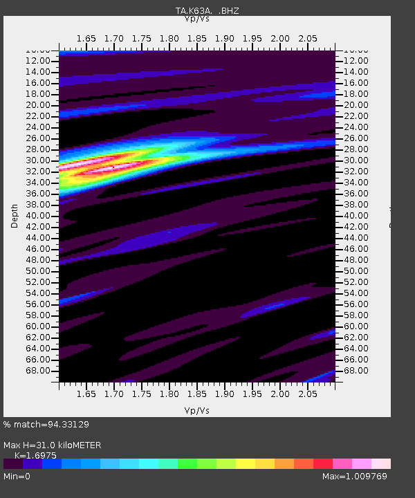
K63A Dunstable, MA, USA - Earthquake Result Viewer

Earthquake location: Off Coast Of Northern California
Earthquake latitude/longitude: 40.8/-125.1
Earthquake time(UTC): 2014/03/10 (069) 05:18:13 GMT
Earthquake Depth: 17 km
Earthquake Magnitude: 6.8 MW, 6.8 MWR, 6.9 MWW, 6.9 MWB, 7.0 MI, 7.0 MWC
Earthquake Catalog/Contributor: NEIC PDE/NEIC COMCAT
Network: TA USArray Transportable Network (new EarthScope stations)
Station: K63A Dunstable, MA, USA
Lat/Lon: 42.69 N/71.53 W
Elevation: 68 m
Distance: 39.5 deg
Az: 69.009 deg
Baz: 286.076 deg
Ray Param: 0.07494872
Estimated Moho Depth: 31.0 km
Estimated Crust Vp/Vs: 1.70
Assumed Crust Vp: 6.419 km/s
Estimated Crust Vs: 3.782 km/s
Estimated Crust Poisson's Ratio: 0.23
Radial Match: 94.33129 %
Radial Bump: 353
Transverse Match: 81.78354 %
Transverse Bump: 400
SOD ConfigId: 626651
Insert Time: 2014-04-21 03:13:32.020 +0000
GWidth: 2.5
Max Bumps: 400
Tol: 0.001

Signal To Noise

ChannelStoNSTALTA
TA:K63A: :BHZ:20140310T05:25:12.000006Z4.64009052.077232E-64.476706E-7
TA:K63A: :BHN:20140310T05:25:12.000006Z1.6694784.021331E-72.4087356E-7
TA:K63A: :BHE:20140310T05:25:12.000006Z5.1549191.180536E-62.2901153E-7
Arrivals
Ps3.6 SECOND
PpPs12 SECOND
PsPs/PpSs16 SECOND