L50A Kingsville, ON, CAN - Earthquake Result Viewer
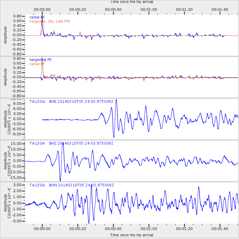
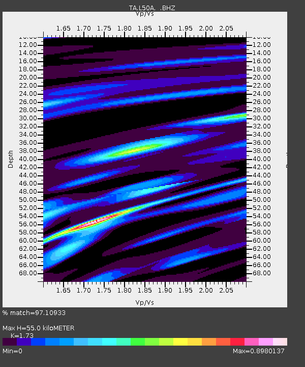
Earthquake location: Off Coast Of Northern California
Earthquake latitude/longitude: 40.8/-125.1
Earthquake time(UTC): 2014/03/10 (069) 05:18:13 GMT
Earthquake Depth: 17 km
Earthquake Magnitude: 6.8 MW, 6.8 MWR, 6.9 MWW, 6.9 MWB, 7.0 MI, 7.0 MWC
Earthquake Catalog/Contributor: NEIC PDE/NEIC COMCAT
Network: TA USArray Transportable Network (new EarthScope stations)
Station: L50A Kingsville, ON, CAN
Lat/Lon: 42.04 N/82.81 W
Elevation: 187 m
Distance: 31.5 deg
Az: 73.599 deg
Baz: 282.235 deg
Ray Param: 0.07902842
Estimated Moho Depth: 55.0 km
Estimated Crust Vp/Vs: 1.73
Assumed Crust Vp: 6.483 km/s
Estimated Crust Vs: 3.747 km/s
Estimated Crust Poisson's Ratio: 0.25
Radial Match: 97.10933 %
Radial Bump: 195
Transverse Match: 88.33099 %
Transverse Bump: 400
SOD ConfigId: 626651
Insert Time: 2014-04-21 03:13:40.976 +0000
GWidth: 2.5
Max Bumps: 400
Tol: 0.001

Signal To Noise

ChannelStoNSTALTA
TA:L50A: :BHZ:20140310T05:24:03.875006Z20.2630713.1672014E-61.5630411E-7
TA:L50A: :BHN:20140310T05:24:03.875006Z2.18174674.5131466E-72.0685934E-7
TA:L50A: :BHE:20140310T05:24:03.875006Z14.5130721.965425E-61.3542447E-7
Arrivals
Ps6.7 SECOND
PpPs21 SECOND
PsPs/PpSs28 SECOND